


ROAD INVENTORY AND AUTOMATIC VISUAL INSPECTION IN CHILE
CARLOS RUIZ TREVIZAN, National Highways Laboratory Department, Highway office, Chile
INTRODUCTION
In recent years in Chile, activities have been intensified to improve traditional road maintenance management systems, innovating and diversifying the management systems of road conservation activities, incorporating road network systems, service levels, road concessions, execution and maintenance of basic roads (low cost roads) and maintenance by Direct Administration (using its own personnel and resources of the National Road Directorate of Chile).
SOLUTION
One of the main axes to support this sustained growth in road management currently in Chile is the information provided by the Road Inventory and Visual Inspection of Paved Roads, which is done through automated equipment. This equipment with digital cameras, bars with lasers and bars with geophones are mounted on a vehicle which travels on the road at the same speed of flow and collects much of the information that is needed. IRI data can be obtained, cracking, road geometry, signaling, lighting, road safety, demarcation and shoulder data, among other parameters. The data is stored immediately and can be transferred to any database format required by the network administrator (see Figure 2.1.5.4).

Figure 2.1.5.4: Automated Visual Inspection Equipment
The captured and georeferenced digital images are entered into a program to identify the types of deterioration present in the roadway and a severity is assigned to then compute the deteriorated areas. The structural and functional deteriorations are then entered into the ICP indicator (Pavement Condition Index) to determine the qualitative and quantitative condition of the pavement. The ICP indicator corresponds to an own design of the Road Directorate of Chile and is the product of an extensive and complete study of behavior of the pavements, framed this in the implementation of a robust system of management of the pavements.
Another technology that has gone in breakthrough is the Georradar, which is a non-destructive technique that is based on the emission and propagation of electromagnetic waves in a medium, with the subsequent reception of the reflections that occur in their discontinuities. The application in a first stage of 5,500 kilometers of pavements, complemented with the extraction of witnesses of pavements and exploration shafts on the side of the roads, allowed to update and correct a large part of the road inventory of paved roads in terms of characteristics and types of materials that make up the road surface.
Currently in Chile, and after several periods performing the visual inspections of pavements by manual means and with personnel from the National Road Directorate itself, it has been decided for 4 consecutive periods to carry out a large percentage of this task through consulting contracts and with automated means. In 2017 they were tendered in the National Roads Authority of Chile 13,404 kilometers of automated auscultation of about 14,834 total kilometers evaluable, representing 90.4%. This growth in the automated visual inspection of pavements carried out in Chile can be seen in Figure 2.1.5.5.
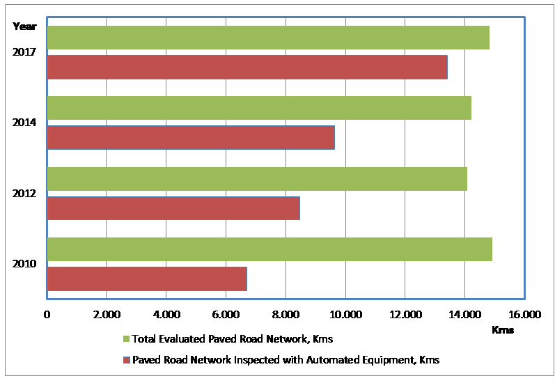
Figure 2.1.5.5: Inspection of Paved Road Network with Automated Equipment
With the results of this automated visual inspection, a large amount of parameter information is obtained from the paved network, which allows the execution of the HDM-4 software to develop periodic maintenance projects that maximize social benefits and provide a greater social return of investment in the country's road infrastructure. These projects are proposed to each of the 16 Regional Road Directions in which the country is administratively divided to be considered in the prioritization of the works that will be executed in the short term and in the relevant budgetary processes. In addition, the automated visual inspection allows tracking the status of the paved road network of the country so that the community and the authorities of the country have a global knowledge of its evolution as shown in the following Figure 2.1.5.6:
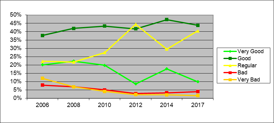
Figure 2.1.5.6: Evolution of the Paved Roads Network Condition in Chile
CONCLUSION
This summarizes the activities and results obtained from the process described above, which is currently carried out in Chile to manage the entire paved network under the responsibility of the National Roads Department. More information on this can be found on the website of the Roads Department of Chile according to the link: http://www.vialidad.cl/areasdevialidad/gestionvial/Paginas/Informesyestudios.aspx