4.3.7.6 ZEB system and control loop of condition information
All pavement condition data and information are affected by a life cycle. They are either in the phase of acquisition, i.e. monitoring and assessment within the framework of a ZEB project, or in the phase of utilization or application.
These two phases of the life cycle of the condition data are closely related to the life cycle of the road infrastructure. In accordance with the terminology of the ISO 19650 standard, the two phases mentioned above can be referred to as the delivery phase (providing the condition data for use in the operational phase) and the operational phase.
The data model of condition data at the delivery phase is called in ISO 19650 the Project Information Model (PIM). In the subsequent operational phase, the condition data are part of the digital model of the entire road infrastructure, i.e. the Asset Information Model (AIM).
Since the pavement condition changes continuously, the condition data must also be updated periodically (see Figure 4.3.7.6.1). The distinctive events (according to the ISO 19650 standard), such as the transition from the operational phase to the delivery phase (B), are also shown in this figure. The index indicates which ZEB project is concerned. The explanations of these distinctive events can be found in the further part of the present document.
As a rule, the ZEB project is repeated every 4 years. During the delivery phase (ZEB project), the current condition data from the road infrastructure Asset Information Model are still used. Directly after, the updated condition data is transferred to the Asset Information Model and the previous condition data is historicized for use in analyzing condition changes.
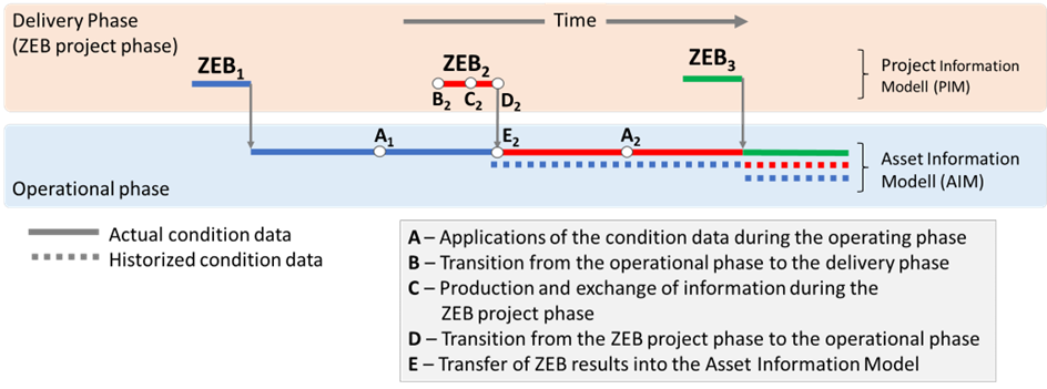
This permanent change between the phases of delivering and operating is represented in ISO 19650 as a control loop of information (see Figure 4.3.7.6.2). The distinctive events (based on ISO 2018) / activities (A to E) are described below.
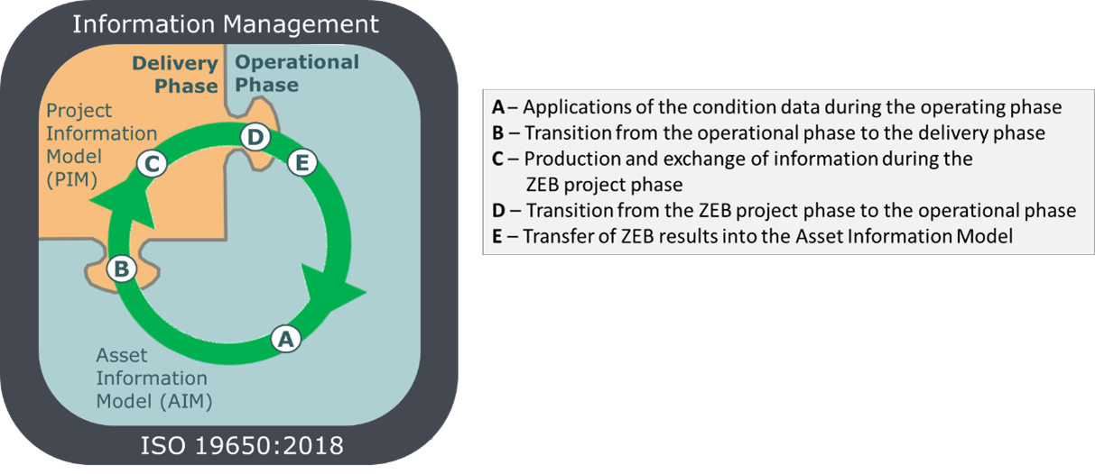
A - Applications of the condition data during the operating phase
In the operational phase, the network-wide condition data are used for numerous tasks at all decision-making levels. Some examples of such tasks are given in Chapter 4.3.7.4. In most cases, the condition data integrated in the digital model of the network, i.e., the Asset Information Model (AIM), is used. However, some special applications require raw data or special indicators that are not available in the AIM. In such cases, appropriate professional systems are used.
B - Transition from the operational phase to the delivery phase
Event (trigger) "B" in the control loop of condition information refers to the initialization of a ZEB project. The client (usually the operator of the road network) formulates the requirements for the results of the pavement condition monitoring and assessment. These requirements cover the formats of the GEO raw data as well as the formats of the result files and the files with images. In ISO 19650, these requirements are referred to as Asset Information Requirements (AIR). Meeting these requirements ensures that updated condition data can be imported directly into the operator's Asset Information Model after finishing the ZEB project.
In addition, requirements are formulated for the entire monitoring process, for quality control, for data exchange between the actors, and for data provision, including deadlines for all milestones scheduled in the project. These requirements are referred to in ISO 19650 as Exchange Information Requirements (EIR).
Both groups of requirements, i.e. Asset Information Requirements and Exchange Information Requirements, are components of the tender documents.
Within the framework of a tendering procedure, the client selects one or more contractors to be commissioned with monitoring (data collector) and one consultant, who is independent of the data collectors. The consultant's tasks correspond to those of the BIM coordinator, but go beyond this and extend to professional activities.
One of the consultant's tasks is to set up and operate an IT system that serves as a Common Data Environment (CDE) on the one hand and is equipped with advanced modules for assessment and other analysis on the other. The general requirements for the functionality of the CDE in all phases of the ZEB project are formulated in the respective tender documents. They comply with ISO 19650's BIM Implementation Plan (BIP).
In addition to the classic tasks of a BIM coordinator, the consultant has to fulfill a number of professional tasks, which are particularly related to quality management. These tasks include, among others:
- Ongoing control of the monitoring progress and reporting to the client,
- Quality control of the recorded data and images based on various criteria, including engineer-specific criteria,
- Aggregation and assessment of the pavement condition data as well as transformation of the ZEB results into the required formats for transfer to the operator's Asset Information Model,
- Documentation and visualization of results.
C - Production and exchange of information during the ZEB project phase
The ZEB project is characterized by a very high level of complexity. Large amounts of data and information are exchanged between the involved actors and along the interfaces between the realization phases. Any disturbances in this exchange of information at these interfaces would have a negative impact on the efficiency of the entire ZEB project and cause delays in the delivery of condition data, which in turn would have a negative impact on the routine tasks of the operators and owners.
For this reason, the client formulates strict requirements in the document - EIR (Exchange Information Requirements) for meeting the deadlines for the individual milestones and for the quality of the data and results. The three objectives are followed:
- Ensuring required quality of condition data,
- Meeting the deadlines set, and
- Risk optimization.
Although the ZEB projects have already been implemented for several years using the same procedures and one might think that they have therefore reached routine status, the complexity of the project and the numerous risks indicate that a high degree of flexibility is also required in the design of the entire approach.
The prerequisite for meeting these demanding requirements for ZEB projects is the support of professionally qualified staff that understands the requirements of the client and acts accordingly, as well as the implementation and operation of an IT system with the CDE functionality and with other features for solving specialized tasks. The Customer formulates the requirements for the functionality of such IT system that will be applied throughout the project phase.
The OnKo system is used as the CDE platform for the ZEB in almost all ZEB projects in Germany. Since its first deployment in 2007, the CDE/OnKo platform has been used in ZEB-projects in Germany and abroad, managing condition data on a coverage length of more than 700 thousand lane kilometers only on federal highways and state roads.
D - Transition from the ZEB project phase to the operational phase
The ZEB project ends with the handover of all contractually agreed delivery objects, i.e. the GEO raw data files, the RASTER raw data files, the results files, the files with route and surface images as well as the documentation and visualization of the results by the consultant to the client. The amount of data is considerable. For example, a ZEB project for state roads in Baden-Württemberg in 2020 generates more than 8 terabytes of data.
E - Transfer of ZEB results into the Asset Information Model
Most of the digital models of the road infrastructure (Asset Information Model) of the federal states in Germany are limited to the management of aggregated data, i.e. the condition quantities and values for the individual evaluation sections (100m/20m). Often the road images are also included. The raw data are usually not included in these models.
Deviating from such approach, some federal states, including Baden-Württemberg, have decided to use the CDE/OnKo - platform not only during the ZEB project, but also after its completion as a supplement to the digital model of the road infrastructure (Asset Information Model). So OnKo takes on another role, no longer as a CDE - platform, which it played during the ZEB project, but as a specialized system for the assessment and providing of pavement condition data.
The GEO raw data managed on the OnKo platform meet the requirement: "Single Source of Information" and thus, as a continuation of the CDE in the ZEB project, represent the original source for all pavement condition indicators generated from the GEO raw data, in particular condition quantity and condition values. OnKo is also equipped with a WFS (Web Feature Services) to integrate the condition data and images into third-party applications. The geographic layers with the condition classes can be integrated into external GIS applications using WMS (Web Map Services).
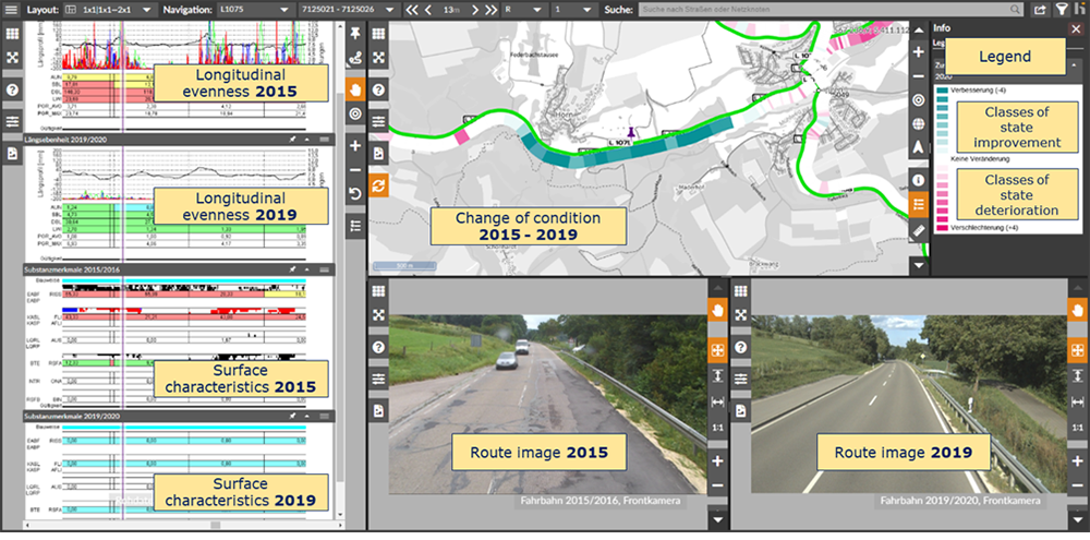
Furthermore, OnKo has the functionality to project condition data from previous ZEB projects onto the current road network and thus realize so-called dynamic data evaluations. Figure 4.3.7.6.3 shows an example of such an assessment of the dynamics of pavement condition.