


4.3.7.5 Requirements on the system for monitoring and assessment of condition data
To ensure that the pavement condition data is suitable for the above-mentioned applications, it must permanently meet certain requirements.
The following three roles are always foreseen among the actors in the pavement condition monitoring and evaluation projects:
- Client (e.g., the owner or operator of the road network),
- Data Collector and
- Consultant of the client.
The most important requirements for the system for monitoring the pavement condition data include (Heller, 2011):
- Standardization of data and procedures,
- Task-neutral monitoring and task-oriented assessment,
- Efficient providing of the condition data and assessment results, and
- Sustainability.
Standardization of data and processes
All processes of data monitoring and assessment must be kept stable over a longer period of time in order to ensure one of the most important requirements, namely the comparability of the condition data over time. This comparability over time is crucial, among other things, for the generation of prognosis models. At the same time, it must also be possible to compare the data between the administrations (between the sub-networks). Such spatial comparability is, in turn, a prerequisite for achieving the envisaged network consistency, which is an important strategic goal from the perspective of a road network owner's. Since pavement condition has a significant impact on driving comfort and safety, it is considered an important factor for this network consistency. In addition, the quality of the condition data must be ensured according to clear and standardized criteria in order to guarantee the comparability of the results of the pavement condition studies.
These requirements can only be met if the entire process for monitoring and assessment of the pavement condition data is standardized. In Germany, the ZTV-ZEB-StB (FGSV, 2006) represent such a standard.
Task-neutral monitoring and task-oriented assessment of pavement condition data
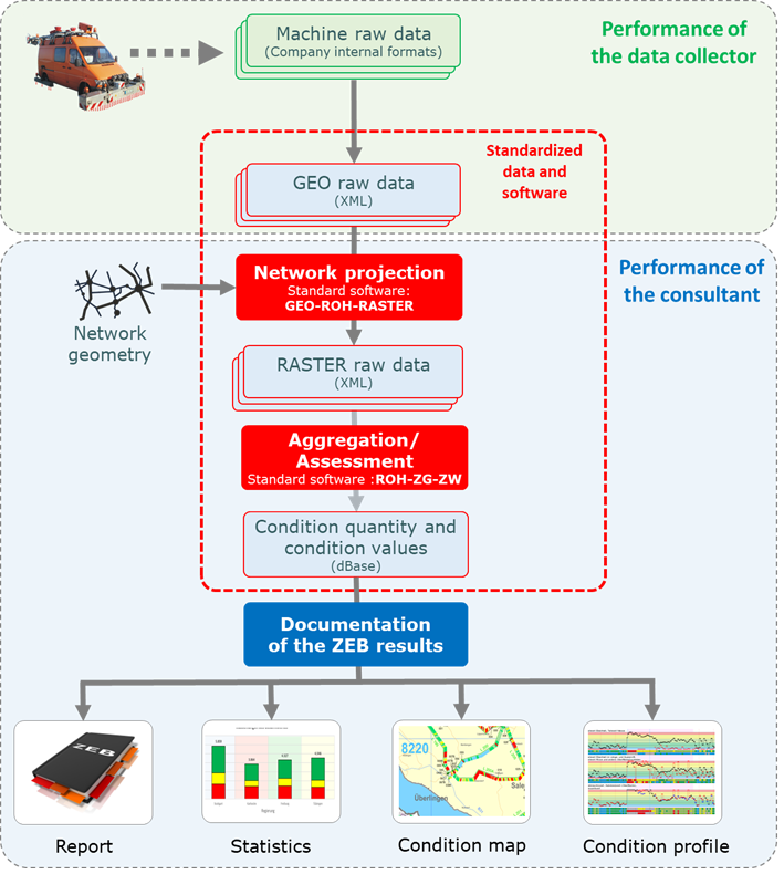
The ultimate result of the pavement condition monitoring is georeferenced raw data, so-called GEO raw data, in high resolution. They are delivered in files in defined and documented formats. Figure 4.3.7.5.1 shows a section of a GEO raw data file with longitudinal evenness data. The GEO raw data also includes the georeferenced route images as well as the high-resolution surface images, which provide the basis for the manual or automatic detection of surface properties in the later assessment phase.
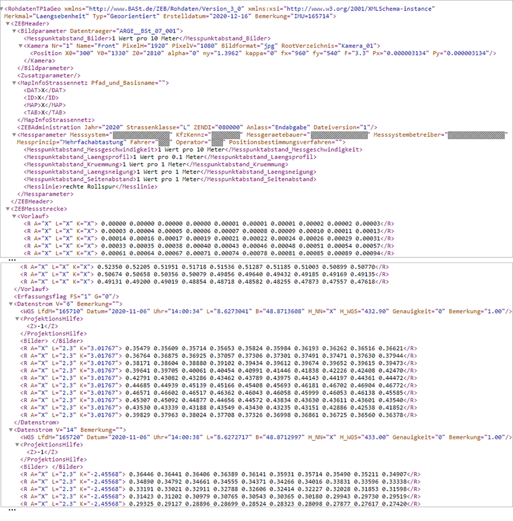
In GEO raw data, the entire data stream is typically referenced every 10 meters to a point whose location is uniquely determined by geographic coordinates.
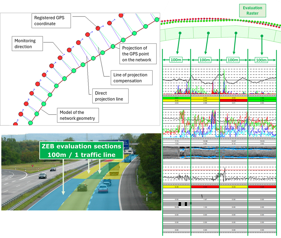
For practical purposes, these GEO raw data must be assigned onto the network, i.e. onto the linear referencing system. Because the projection is done on the road axis and because of the inaccuracies in the recording of the coordinates, the raw data stream must be stretched or compressed accordingly. Since different methods can be used, the process of data projection is standardized and a freeware standard software (GEO-ROH-RASTER) is provided for these purposes by the federal authorities BASt (German Federal Highway Research Institute).
The GEO raw data projected onto the road network are aggregated in the data segments of an evaluation raster. One data segment of the raster corresponds to the ZEB evaluation sections of 100m in non-urban areas and 20m in urban crossings and is uniquely localized by means of the kilometers of the beginning and the end as well as by the indication of the traffic lane. All localization information must correspond to the current network model in the Asset Information Model (AIM).
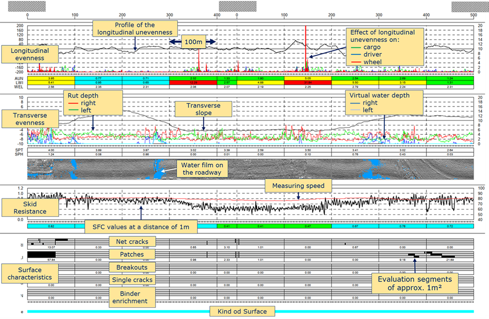
The RASTER raw data generated in this way provided the basis for the computation of the pavement condition quantities and values, as well as for the visualization of the raw data, as shown on Figure 4.3.7.5.2.
The GEO raw data is the basis for further assessments:
- Projection of the GEO raw data on the road network to perform linear referencing as a secondary referencing system. As a result, RASTER raw data are generated.
- Aggregation of the RASTER raw data for the evaluation sections of 100m on nonurban roads or 20m length in urban roads and calculation of the condition quantities for these ZEB sections (e.g. IRI [m/km] or rut depth [mm]).
- Condition assessment, i.e. calculation of the condition values (as notes in a uniform scale system) and the complex condition values (surface), e.g. substance value or usage value.
Figure 4.3.7.5.4 shows the major standardized assessment steps of the pavement data.
If, due to new research insights, the algorithms for determining the condition parameters change or new or alternative characteristics are defined, it is always possible to assess the historical GEO raw data from the previous ZEB projects according to the new algorithms and thus validate the object- and network-related consequences of such modifications.
The raw data also provide the basis for a wide range of applications, including those that were not known at the time of the survey. This high degree of flexibility is achieved by making the monitoring process somewhat 'task neutral', by giving the raw data the status of an ultimate data source and by standardizing its format.
In this way, the raw data can be used as a basis for further assessments that go over and above maintenance planning. For example, skid resistance data aggregated to 100m are of limited value for object-based analyses of traffic safety. Therefore, the indicators are calculated based on the moving average of 1-m measurement results, which are then linked to geometry data such as curvature. This allows areas with road safety gaps to be identified much more accurately and targeted.
In the meantime, there are also numerous other applications for the pavement condition data beyond road administration that benefit from the availability of the raw data, e.g. in the automotive industry. Even the route images recorded as part of ZEB, which were originally used only to check the plausibility of the condition data, are now being applied massively for various other purposes. The fact that these images are available network-wide in the same resolution and the required quality makes them a good basis for comprehensive photogrammetric assessments.
Efficient providing of the condition data and assessment results
As mentioned above, the real value of condition data and information is determined by their impact on specific decision-making processes . Providing the condition data in a suitable aggregation level and presenting or visualizing it in a suitable form are therefore of fundamental importance. As a result of ZEB, statistical assessments and visualizations in the form of diagrams, maps and profiles are thus provided in addition to the pure condition data (raw data, condition quantities and condition values as well as road or surface images). The raw data are also presented in a corresponding form on so-called raw data profiles (see Figure 4.3.7.5.2).
Since the spread of online technologies, it is expected that all relevant data and results are also available online for authorized users.
Sustainability
The described ZEB procedure was first introduced by the federal government in the early 1990s for the federal motorways. In the meantime, it is used by all German federal states and by many counties and cities. Even though the scope and procedure of the evaluation procedures are often adapted to the local circumstances in the individual federal states or counties, which is made possible by the principle of task-based assessment, the general approach of ZEB must remain unchanged over the years.
In order to ensure the long-term comparability of the results despite the shareholding of different actors, the BASt has commissioned the development of special software for all relevant evaluation steps, which is made available free of charge to all companies involved in ZEB projects. The software is continuously maintained and kept up to date.