


LEARNINGS FROM IMPLEMENTATION OF ROAD ASSET MANAGEMENT SYSTEM IN ASSAM, INDIA
RAJESH KEMPRAI, Commissioner and Special Secretary to Government of Assam, Public Works Roads Department, India
DIGANTA GOSWAMI, Assistant Executive Engineer, Public Works Roads Department, Government of Assam, India
Introduction
Public Works Roads Department (PWRD) is the agency responsible for managing the secondary, urban and rural road network in Assam. To boost infrastructure development, it had initiated several projects in the state and Assam State Roads Project (ASRP) being one of them. The State Government of Assam (GoA) through the Government of India (GOI) has received a loan from the International Bank for Reconstruction and Development (IBRD) for implementation of Assam State Roads Project. Development and implementation of a computerized road asset management system (RAMS) for the maintenance and management of the state road network is one of the key mandates of ASRP. Consequently, such a system was developed and implemented during 2015-18 to meet the needs of PWRD and is called Assam Road Asset Management System (ARAMS). The ARAMS application is envisioned to assist the PWRD to rationalize and aid the decision-making for planning / programming of road maintenance and rehabilitation activities and to estimate the long-term funding requirement for preserving the road assets at an acceptable service level, thereby safeguarding their asset value. It is intended to reflect the state-of-the-art technology and best international practices, in a way that suits the local needs and conditions. To achieve this, PWRD retained LEA Associates South Asia Pvt. Ltd. (LASA), India in joint venture with LEA International Limited (LEA), Canada in association with Geo Info Space Private Limited (GIPL), India. This report offers insights to the project tasks and major findings / learnings for PWRD from the Project.
Objectives
The principal objective of the project was to establish and implement a road asset management system (RAMS) for PWRD. The project envisaged following tasks under its scope of work:
- Develop a web-GIS based software applications incorporating layers of engineering and economic criteria, database of road network and structures inventory, condition, and traffic data; tools to input, store and analyse the data based on agreed system and functional requirements of the department’s user;
- Prepare a Data Collection Manual and collect road, bridge and traffic data from the field on SH (State Highways) and MDR (Major District Roads) for nearly 7500 km using established methods and modern data acquisition equipment. Data collection of another 36,500 km of rural road network and updating the data to the same database was further added as variation to this project;
- Process field data and upload in ARAMS database to diagnose the pavement performance;
- Develop asset management policies, strategies and implementation plan for PWRD to effectively manage their assets;
- Set-up and implement the system in the data centre of PWRD, and impart training on data collection and system use to PWRD staff for sustainability;
- Develop multi-year rolling plans for capital works including road improvement, rehabilitation and pavement strengthening, road safety improvements, bridge replacements and repairs, and various improvement works (spot improvements) to bring the roads to the desired level of service;
- Develop annual maintenance plans for periodic, routine, special, and emergency repairs;
- Optimize funding to maintain the network in a defined level of service;
- Prioritize sections for a fixed budget and / or allocate funds from various funding sources to the road sections prioritized using customized rational criteria;
- Prepare network level reports on asset value, road condition, road capacity, safety ratings, safety hazards, traffic levels, historical trends etc.
Benefits
The major benefits expected from the project to PWRD are manifold. A few of them are listed below:
- Provide improved internal and external communication regarding asset information for more effective management within and outside the department;
- Improved data quality, consistency, and credibility because of adoption of standardized data collection, analytical, evaluation methods;
- Help PWRD to choose cost-effective, optimal, sound design, maintenance and rehabilitation policies, by comparing alternative maintenance/rehabilitation strategies;
- Evaluate and prioritize widening, rehabilitation, and maintenance works based on engineering, traffic, economic and social parameters;
- Review asset conditions as an outcome of resources/budgets committed/spent in the past few years for performance monitoring;
- Predict asset conditions for different funding/maintenance scenarios;
- Review impact of funding levels, or forced decisions on the overall health of the asset to decide desirable funding;
- It can be used as a rational basis for allocating funds for maximum public benefits/returns.
SOLUtion
Assam is the largest state among the North Eastern states of India and acts as gateway for the entire North Eastern (NE) states i.e. Arunachal Pradesh, Manipur, Meghalaya, Mizoram, Nagaland, Tripura and West Bengal and two countries viz. Bangladesh and Bhutan. Its fiscal and economic situation has been improving since last decade, efforts of the government has helped the state to accelerate its Gross State Domestic Product (GSDP).
Its geographical location demands huge thrust on the development of road infrastructure in the region for enhancing the region’s economy. As road infrastructure assets are the key factors of economic development, mobility and social equity for any region or nation. They are not only costly to build but also expensive to maintain in order to adequately meet the public expectations. The key issue is how to manage existing assets in an optimum way and deliver maximum benefit to public, taking into account limited financial resources. The solution is Road Asset Management System (RAMS) which offers a comprehensive and structured approach to deliver benefits to the community benefits through management of road network. It is defined as a systematic process of maintaining, upgrading, and operating road assets cost-effectively. PWRD, under the assistance of the World Bank has developed a web based Road Asset Management System (ARAMS). It is a comprehensive system developed for the road network under PWRD jurisdiction mapped on a GIS platform. It is intended to improve the technical capacities, skills and management capabilities of the PWRD and other road agencies associated with road management and maintenance, thus improving the ability of the Government of Assam (GoA) and its subordinate agencies to manage efficiently and cost-effectively road maintenance and improvement activities.
Road Network
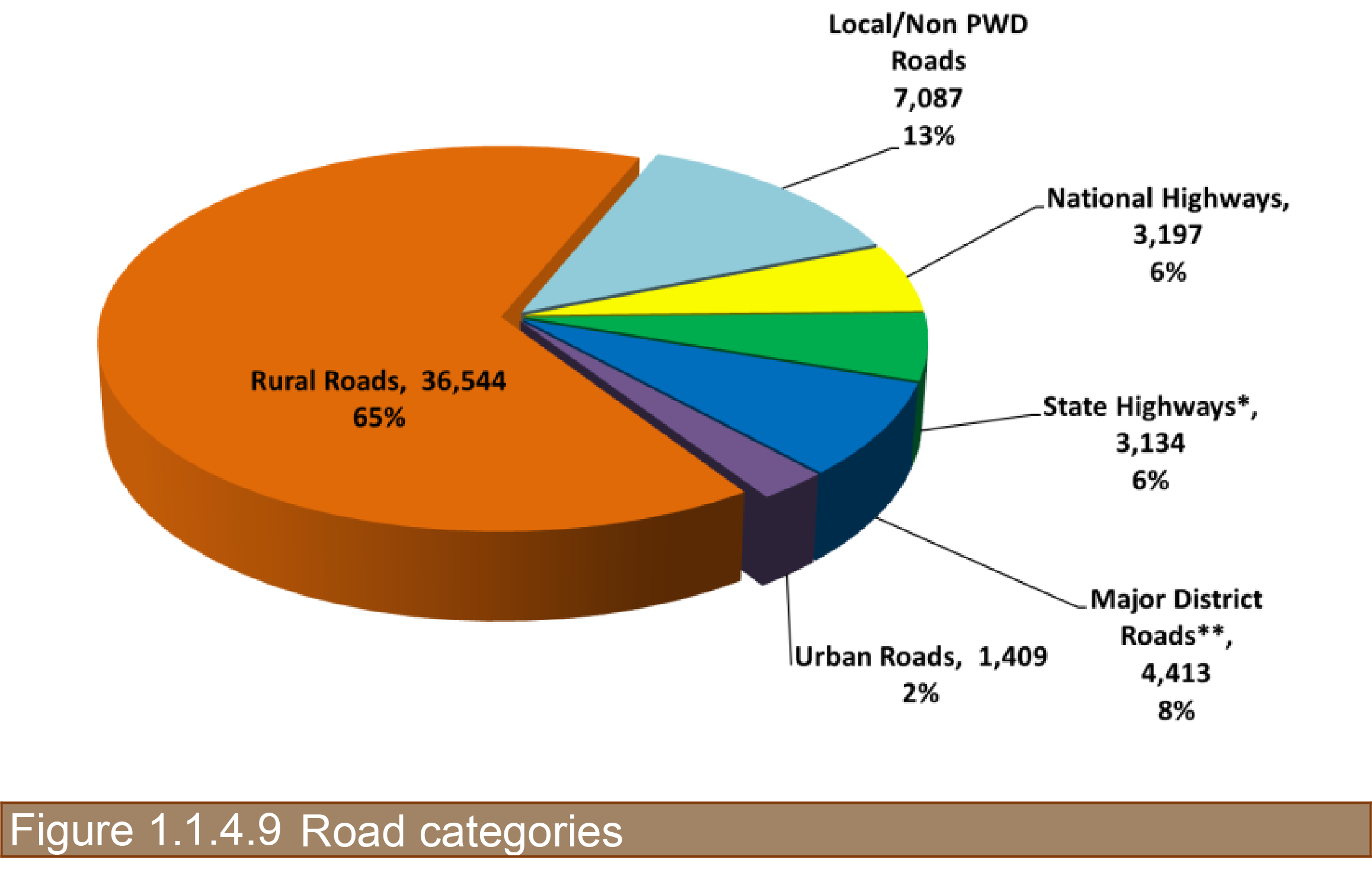
The capital Assets of road agencies in Assam comprised of the road network and assets created thereon such as pavements, bridges, culverts etc. The current road assets in the state are represented in the table. While the National Highways (3,197 km) is managed by a number of agencies (NHAI, PWD-NH & Buildings, BRO, Railways), the Public Works Road Department (PWRD) in Government of Assam manages secondary and tertiary state road network of 44,862 km. The secondary network is classified into State Highways, SH, 3,134 km; and Major District Roads, MDR, 4,413 km, Urban Road 1,409 km and Rural Roads, 36,544 km. The length of rural roads is expected to be around 47,000 km as per RAMS consultant’s estimate, thereby making the total road network under PWRD to about 56,400 km to be managed by the RAMS. About 604 km of SH and 34 km of MDR are taken-up as NH post 2012-13, thereby making total NH as 3835 km.
This case study mainly focuses on the secondary road network i.e. SH and MDR under PWRD which comprises of about 15% of the entire road network of Assam. Of the 7500km of SH and MDR network, about 87% paved road network comprise of bituminous, cement concrete and paver blocks and the remaining 13% is unpaved which also included about 6% (411 km) inaccessible network due to dense forest cover, breached river sections, etc. as represented in the table below:
Table 1.1.4.8: Road network included in case study

About 84% of road network has carriageway width less than 7m i.e. either single or intermediate lane. Only 10% of the road network is of double lane standard and the remaining 6% is inaccessible as represented below:
Table 1.1.4.9: Road width included in case study

There are 1835 bridges and 10798 culverts on SH & MDRs in Assam which also include 101 wooden, 22 semi-permanent steel bridges and 96 bridges are under construction as represented in the table below:
Table 1.1.4.10: Bridges included in case study

Data Collection
Data collection constitutes the most time consuming and resource requiring component for asset management system. It is also subject to budgetary scrutiny and at risk due to financial constraints. In the context of Assam, the data collected was most appropriate to the objectives, resources and modus operandi of the department, and meets the criteria of relevance, reliability, affordability, appropriateness and accessibility. Most of the data was collected through automated means using electronic and mechanical equipment. The consultant procured ARRB’s Hawkeye to collect center-line alignment, inventory, geometry, roughness and condition of the pavement travelling at highway speeds. The data collection methodology implemented for Assam road network is represented below:
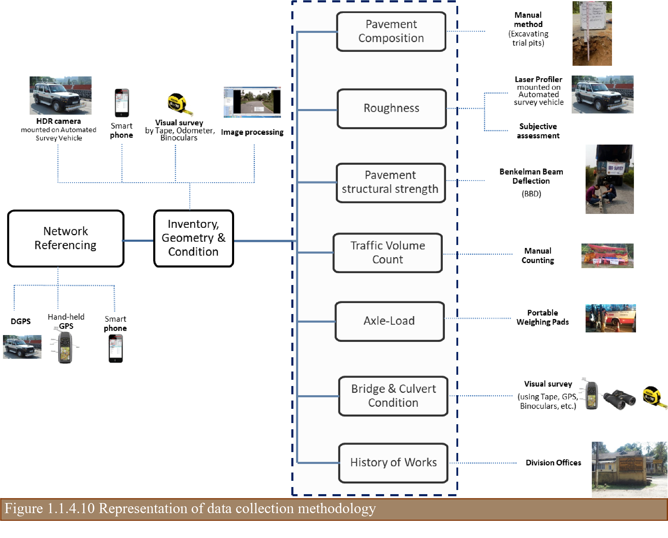
Table 1.1.4.11: Data collection methodology

Road Network Condition (Findings)
Due to years of inadequate investment towards robust design on capital asset creation and lack of maintenance thereon has left the road network in poor condition. Road maintenance is a lower priority as compared to new construction. The advent of flagship schemes such as NHDP (National Highway Development Program), PMGSY (Pradhan Mantri Gram Sadak Yajona – Rural Roads Program), etc. by the Government of India (GoI) has led to negligence towards maintenance of SH and MDR network. Some of the key observations from the surveys carried out by the RAMS consultant are as follows:
- Nearly 80% of roads have narrow road width i.e. less than 7m and 13% of the road network is still unpaved or kuccha roads, of which around 6% i.e. 411 km are inaccessible;
- The standard pavement thickness is very less i.e. about 10 inches or 290mm, which is barely adequate to hold the heavy traffic;
- Most of the roads are carrying heavy axle-loads with no regulations, thereby damaging the pavement life at a faster rate. In high commercial traffic roads, a high vehicle damage factor (VDF) of 11.16 is observed which is very uncommon;
- Poor quality mixes such as Semi-Dense Bituminous Macadam (SDBC) or Premix carpet (PC) are used as surface coat which are porous in nature. Due to high precipitation and heavy axle-loads, these surfaces barely last for only two years only. Poor drainage facility adds up to the current misery;
- More than 90% of the roads do not have any drainage and more than 60% of the road length has built-up sections where permanent drains are necessary;
- Assam being flood prone, most of the road sections are overtopped, thereby leading to early removal of low graded top coat or wearing course;
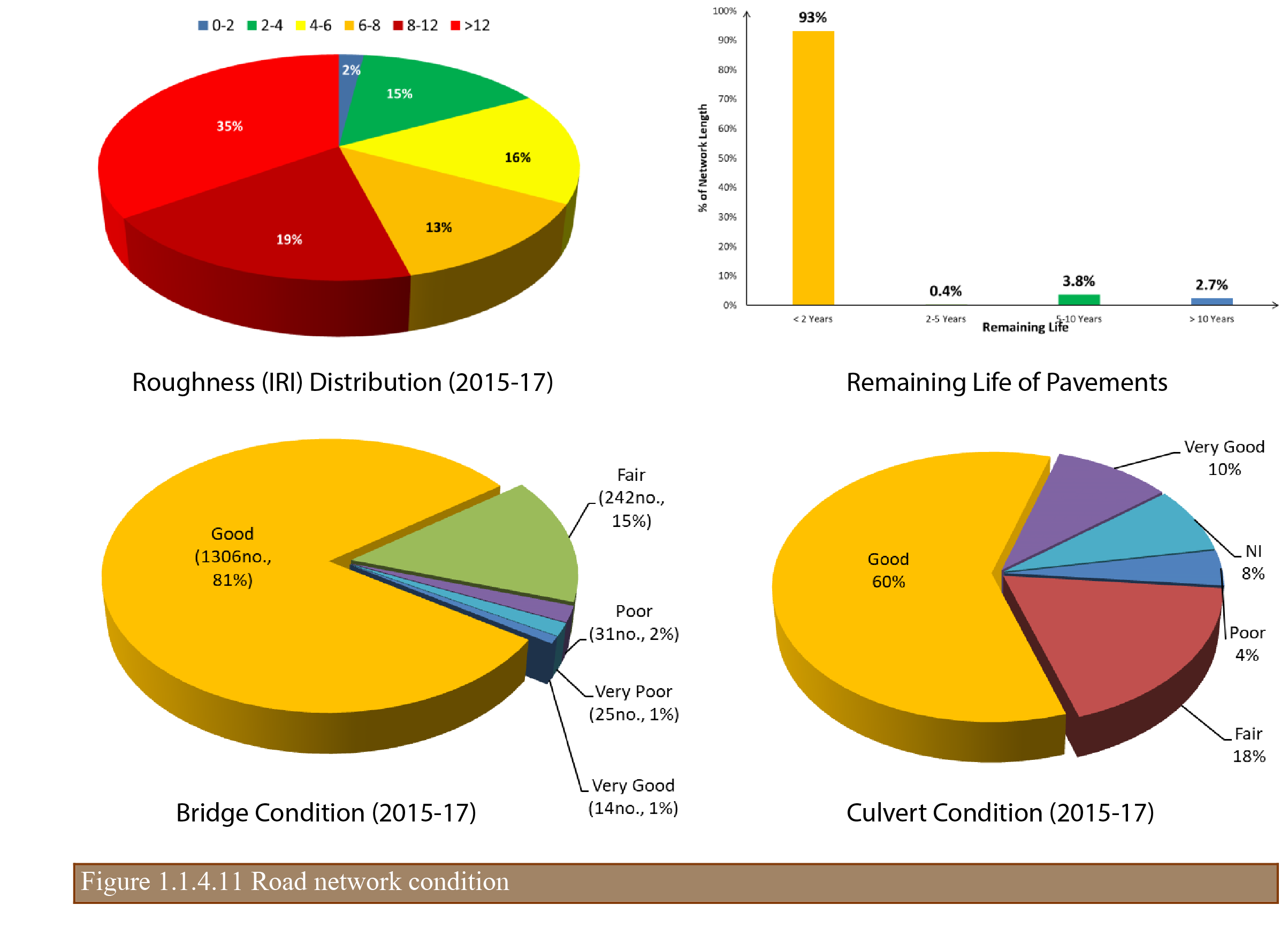
- Only 17% of the road network are smooth or of good riding quality (IRI < 4m/km) and about 35% of roads are failed or in non-motorable state;
- More than 90% of the roads have very less (< 2 year) remaining life and are not maintainable at any cost. They have to be reconstructed only;
- Nearly 123 bridges are semi-permanent which has to be constructed and about 57 bridges are in either poor or very poor condition which needs immediate attention.
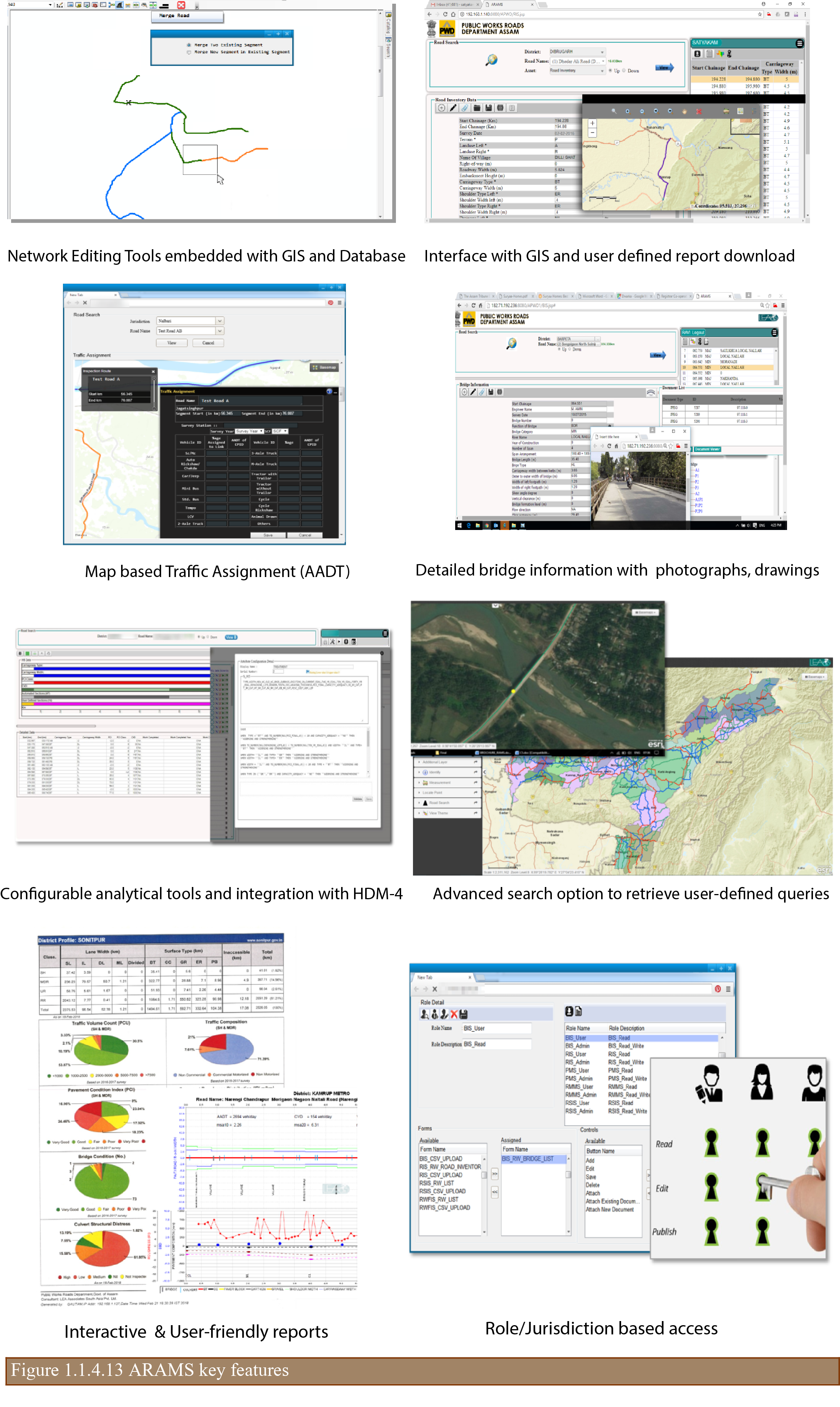
ARAMS Application
ARAMS is a web-based GIS application developed to add, edit, update, view, analyze, monitor and delete the data on roads and bridges under PWRD. It is integrated with PWRD’s online e-portal and hosted in the department’s server located in the Office of the Chief Engineer, PWD (Roads), Chandmari, Guwahati. It primarily consists of 7 core modules:
- Network Manager (NM), embedded with ESRI’s ArcGIS, creates road network comprising of details of road such as road name, jurisdiction, category, road length, direction, etc.
- Road Information System (RIS), stores information about inventory, composition, roughness, pavement condition, structural strength, history of works carried out, etc. of PWRD roads;
- Bridge Information System (BIS), stores information about inventory and condition of the bridges along with high resolution digital images for viewing and store overall rating of bridges with costs;
- Traffic Information System (TIS), stores 7 day 24-hour traffic volume count data for 200 locations collected in three years including storage of seasonal correction factors, PCU (Passenger Car Unit), VDF (Vehicle Damage Factor), etc. It facilitates user to assign traffic over road network using GIS map interface and also calculates msa (million standard axles) for the pavements;
- Right-of-Way Feature Information System (RWFIS), stores location and offset distance of the right-of-way features and represents on a strip map;
- Road Safety Information System (RSIS), stores accident information and calculates accident spots based on the rules configured within RAMS. It also stores information about potential hazardous locations along with remedial measures;
- HDM-4 based Pavement Management System (PMS), allows user to define homogenous sections, generate input files for import to HDM-IV for Programme / Strategy analysis and stores results obtained from HDM-IV for reporting;
- Annual Maintenance Tool (AMT), which uses simplified matrix to determine annual maintenance plan for PWRD. It can be configured based on user-requirements.
In addition to the above, two (2) modules; Web-GIS and Reports were developed to assist PWRD in viewing the information on a GIS map platform and retrieve pre-defined standard reports for administrative use. A schematic representation of the ARAMS system architecture is given below:
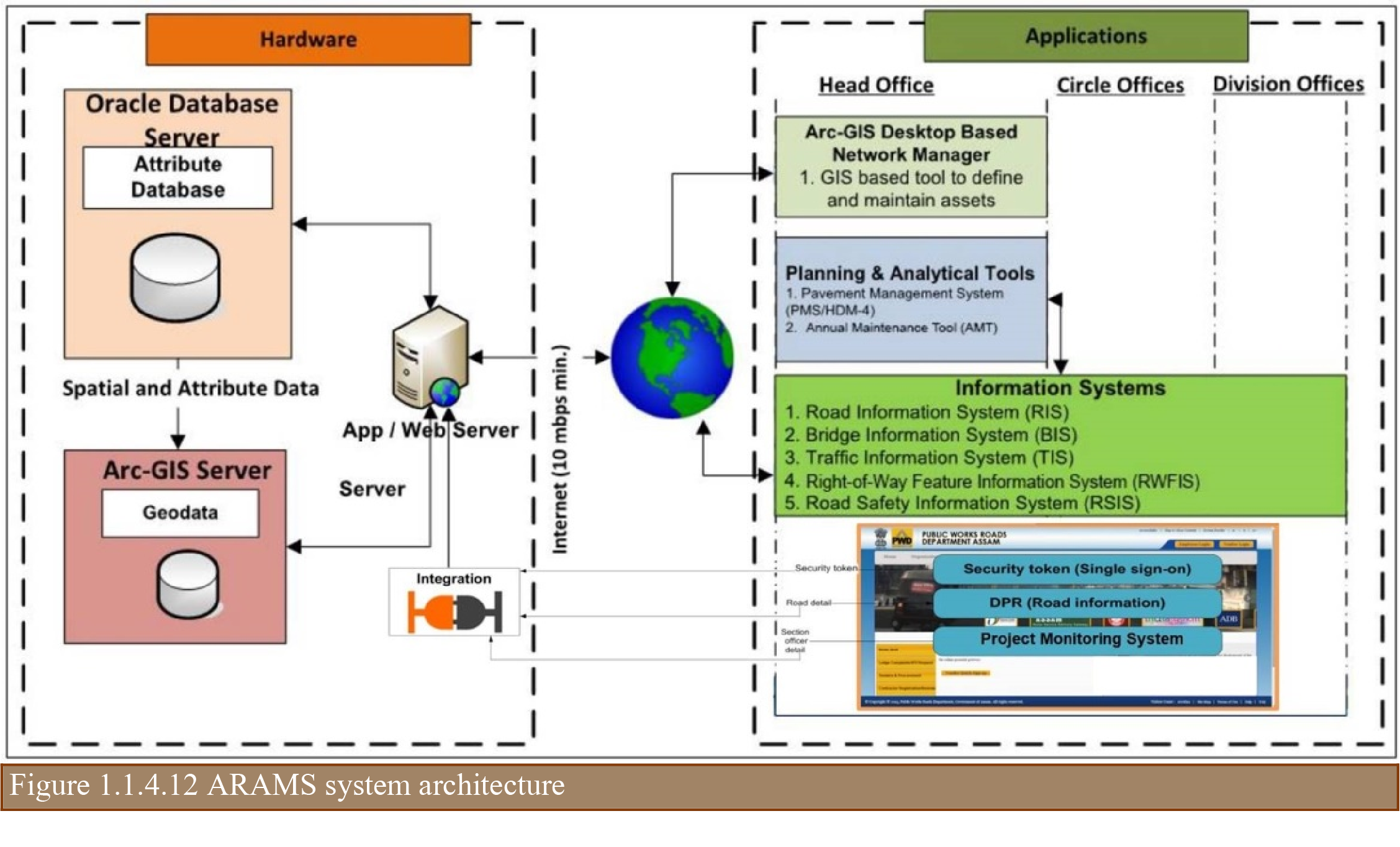
The application suite is developed using Oracle 11g R2 Enterprise Edition and ArcGIS Server 10.4. The client side script uses HTML and JavaScript, and server side script as Java technology. It supports a cross browser, cross platform technology, and runs on all popular web browsers including Microsoft Internet Explorer, Mozilla Firefox and Google Chrome. The system and functional requirements of ARAMS was established after carrying out a detailed needs analysis study and reviewing the software licenses, hardware and networking options available with PWRD for hosting. Some of the interfaces with key features are represented below:
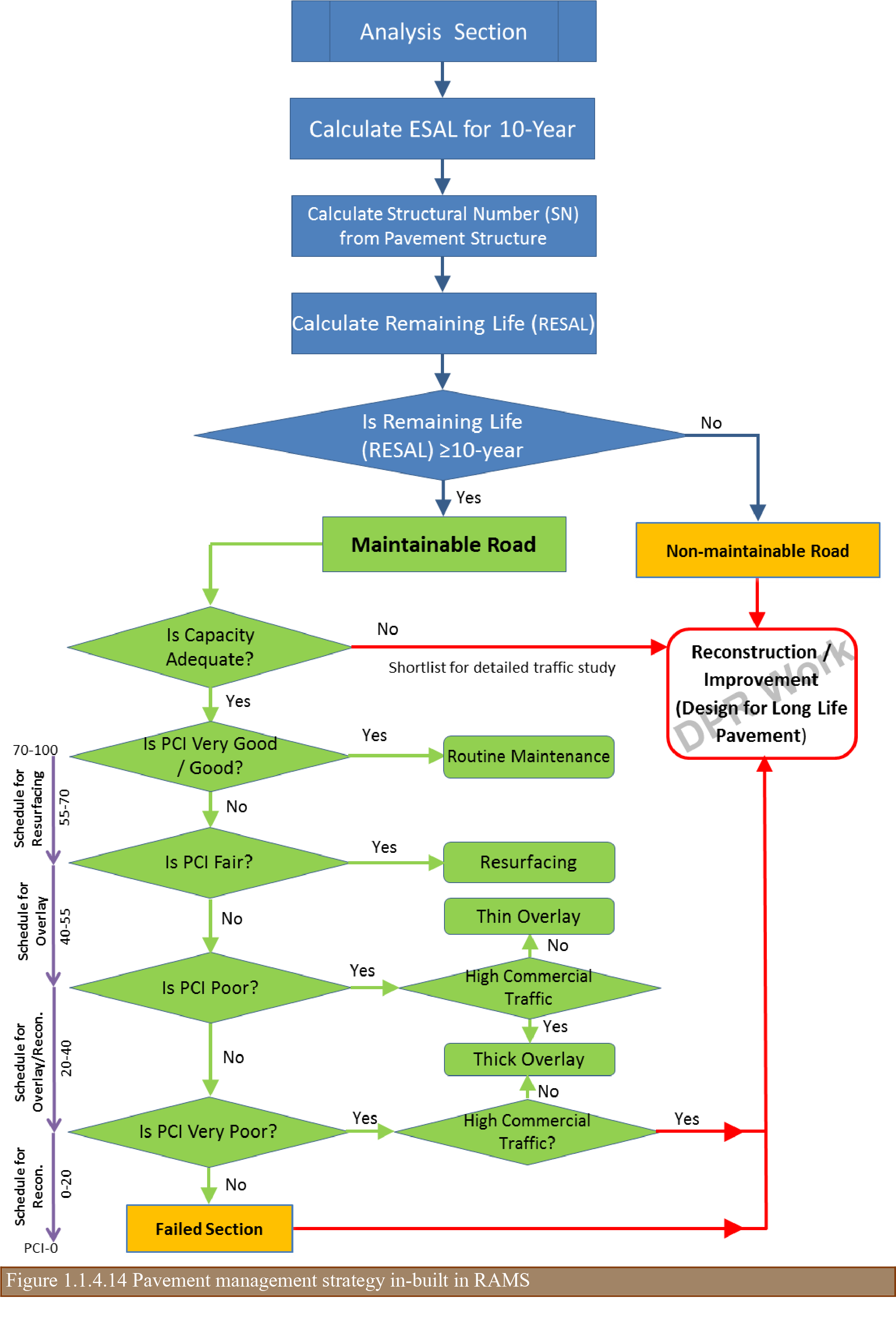
Network Management Strategy
The vast road network with a current asset value of only INR 12,260 crore (USD 1751 million) will further lose its value with time if it is not sufficiently maintained and improved to tackle the distress and traffic demand. Treatments for maintenance and improvements should be suggested for building durable or long-life pavements. To maintain the roads at the desired level of service, adequate and timely provision of budget is also a requisite and should be planned and estimated in advance. A robust network management strategy considering the remaining life of the pavements with emphasis laid on long-lasting pavement (40 year design), use of superior mixes, adequate provision of drainage and raise in embankments to mitigate submergence was developed as listed below:
- Reconstruction (with or without widening) of weak/failed pavements with less remaining life (< 2 year) must be taken up on priority with a long-lasting approach:
- Base and sub-base should be designed for 40 years;
- Bituminous course should be designed for 20 years;
- Intermediate lane sections to be reconstructed for 2 lane facility in anticipation of heavy traffic;
- Maintenance to be undertaken on pavements having more than 10 year life for greater value of money and long-time serviceability. Interim rehabilitation to be done on poor condition roads to make it rideable for couple of years;
- Owing to high precipitation in Assam and observed Vehicle Damage Factor (VDF), minimum 30 Asphaltic Concrete with Polymer Modified Bitumen (PMB) should be preferred over thin 20 mm Premix Carpeting or 25 mm Semi Dense Bituminous Concrete;
- Structurally damaged bridges to be rehabilitated / reconstructed immediately;
- Selection of maintenance, rehabilitation strategies based on rationalized criteria:
- Pavement Condition Index (PCI) / Roughness (IRI);
- Traffic Loading.
Outcomes
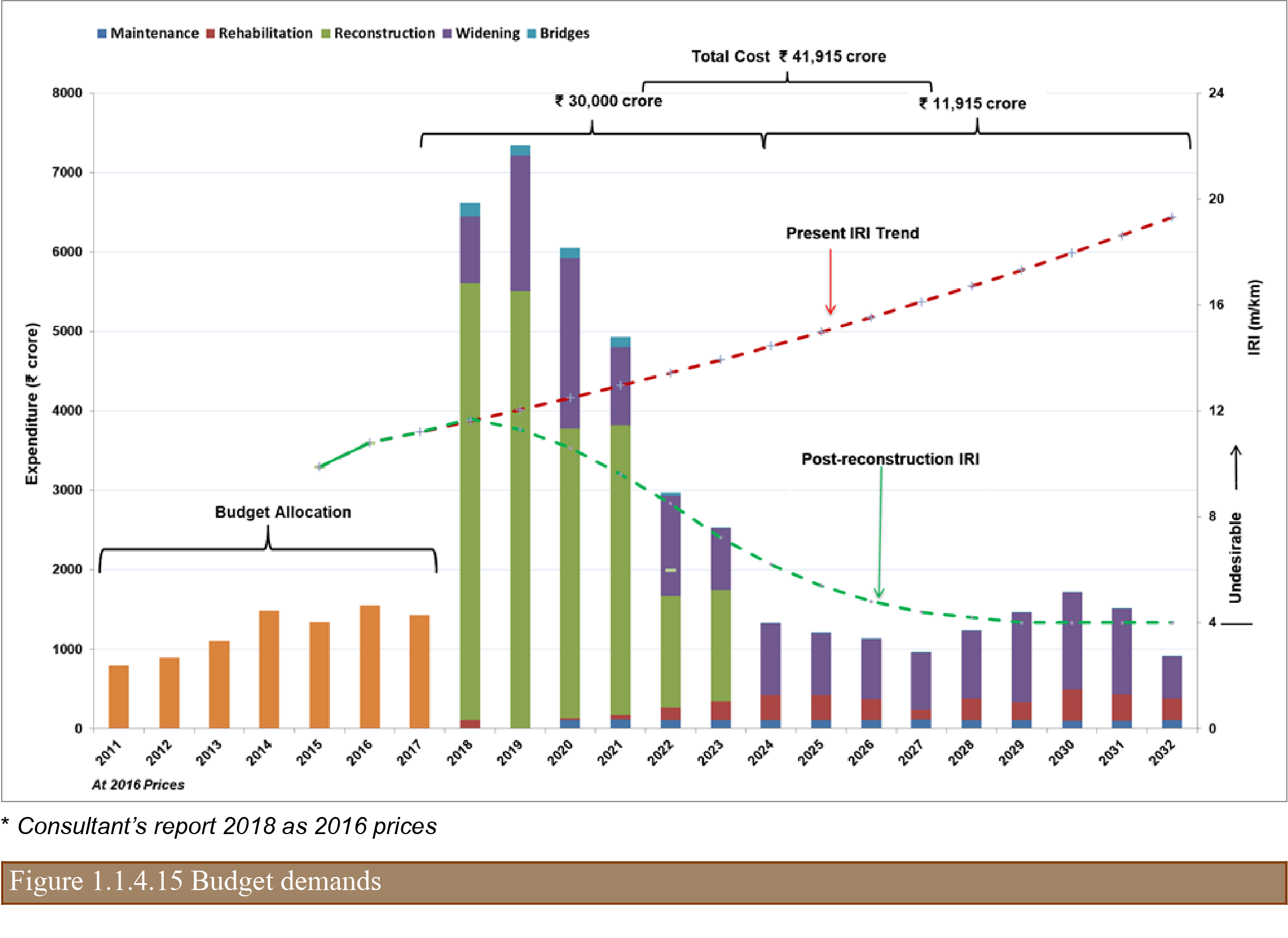
Using the proposed network management strategy and ARAMS application tools, a three-year ‘Action’, a seven-year ‘Strategy’ and a fifteen-year ‘Vision’ plan up to the fiscal year 2031-32 were recommended to rehabilitate the road network and maintain in the desired level of service complying with the planning guidelines of NITI Aayog. The future treatments and costs were based on the current and the anticipated condition of pavements and the expected traffic up to 2031-32. The total requirement for re-construction of SH & MDR by 2031-32 was estimated to INR 41,915 crore (USD 5988 million) and about INR 30,000 crore (USD 4,286 million) in the next 7 years to bring the road network at an acceptable level of service as represented in the graph.
A detailed report on ‘Memorandum to Government of India 15th Finance Commission on Requirement of Funds with Explanatory Notes for Maintenance of Road and Bridge Capital Assets’ was submitted to Finance Commission for their consideration.
As a part of implementation strategy, the state government has also announced the ‘Assam-Mala’ programme. The objectives of this program is to improve the SH & MDR network in the next 15 years for fueling economic growth and bringing the state road infrastructure at par with comparable economies of Southeast Asian countries; to provide quality inter-linkage roads between the National Highways and the rural roads network as well as facilitate seamless multi-modal transportation; and to interconnect economic growth centers with quality transportation corridors and improve inter-state connectivity. The program is expected to have a number of projects under its umbrella. As a major initiative, Government of Assam (GoA) has earmarked INR 5,000 crore (USD 714 million) in the next 3 financial years for improving about 1000 km of road network. It is also planning to rope in additional resources through external funding agencies such as Asian Development Bank, Asian Infrastructure Investment Bank, World Bank, etc. for improvement of another 2000 km road network.
As an interim measure, GoA had also allotted a sum of INR 300 crore (USD 43 million) for maintenance of SH & MDR and PWRD allotted these funds for providing surface renewals / overlay. RAMS application was extensively used to identify the road sections and estimate the maintenance costs for each road sections. The pavement composition, pavement distresses, roughness and deflection, traffic (AADT & CVD), etc. collected on SH & MDR road network in 2017-18 year were reviewed to finalize the road sections.
Conclusion
PWRD has come a long-way in developing a GIS based Road Asset Management System using state-of-the-art equipment for data collection, latest technologies for system development, feel-good user interfaces, and best hardware and network for seamless connectivity and hosting services. Any system developed, if not sustained, will fail one day. To evade such scenario, PWRD has taken up following initiatives towards RAMS sustainability which will be a benchmark / point of reference for other road agencies:
- Outsourced data collection and support for preparation of asset management plans for 3 years under Assam-Mala Programme;
- Set-up a Road Asset Management Cell (RAMC) with dedicated staffing and well-defined mandate to give necessary thrust to the road network planning and budgeting;
- Ownership from the department’s top officials and decision makers and use of ARAMS outputs for identifying various road network improvement programme;
- Training and refresher courses planned in association with Assam Road Research & Training Institute (ARR&TI) to make PWRD engineers thoroughly competent in ARAMS.
References
AASHTO, AASHTO Guide for Design of Pavement Structures 1993 American Association of State Highway and Transportation Officials, Washington, D.C., U.S.A., 1993
Asphalt Institute, Asphalt Overlays for Highway and Street Rehabilitation, MS-17, Asphalt Institute, Lexington, Kentucky, U.S.A.,
Asphalt Institute, Thickness Design Asphalt Pavements for Highways and Streets, MS-1, Asphalt Institute, Lexington, Kentucky, U.S.A., 1991
Federal Highway Administration, Highway Statistics 2014, FHWA, Washington, D.C., U.S.A., Dec. 2015
Indian Roads Congress, Guidelines for the Design of Flexible Pavements for Low Volume Rural Roads (First Revision), IRC:72-2015, Indian Roads Congress, New Delhi, India, 2015
Indian Road Congress, Tentative Guidelines for the Design of Flexible Pavements, IRC:37-2017, Indian Roads congress, New Delhi, India, 2012