
The present section of the manual deals with the most relevant aspects of digitalization and information management from the point of view of the owner and operator of the road infrastructure. It is strictly oriented to the ISO 19650 standard while addressing the context of the entire road network. For the aspects of BIM and digitalization at the project level, please refer to the PIARC report "BIM and Digitalization" (PIARC 2023).
In recent years, digitalization in the construction industry has been accompanied by the term “BIM” (Building Information Modeling). Most practitioners associate BIM with the planning, design, and construction of vertical infrastructure and occasionally with tunnels or bridges. More recently, BIM methods are being applied to horizontal infrastructure.
The term “horizontal infrastructure” is used to describe the entire infrastructure networks, such as roads, railroads, water supply and sewage, telecom, diverse pipelines, etc., under the responsibility of one operator or owner. Horizontal infrastructure consists of linear infrastructure objects, such as road sections, and objects of other types, such as bridges, parking, toll stations or road equipment facilities. The subject of the operational phase of asset management is usually the entire horizontal infrastructure.
The implementations of BIM to date have focused on buildings and, in the road sector, on engineering structures such as bridges, tunnels, complex traffic intersections and sometimes on single linear infrastructures such road sections. At the same time, there are still very few solutions that address overall horizontal infrastructures, such as road networks. The horizontal infrastructures have so far only been accompanied by BIM processes during the planning or construction of their single components. This limitation of BIM to specific design and construction projects ignores the fact that, from the perspective of the operator of the horizontal infrastructure, the entire network, e.g. the national or regional road network, is often the subject of consideration and operational activity.
Such tasks as prediction of maintenance demand in order to achieve specific quality goals, preparation of maintenance programs, or network-related resilience analyses can only be performed successfully if certain information is only available across the entire network. This information must be available at the appropriate quality from the operator's perspective in terms of accuracy, completeness, and timeliness to support its tasks. In the road sector, such data primarily includes as-built data, condition data and traffic data. They are managed in the road information databases maintained by the operators for a particular road network.
Recent experience has demonstrated that the implementation of BIM processes can contribute to an increase in the efficiency of the planning, designing and construction of all transportation infrastructures. Time and cost discipline increases and the risks for owners, designers, constructors and suppliers are reduced.
The use of BIM in the transportation sector is becoming more mature and standards and best practice procedures have been developed, partly thanks to considerable government funding projects, and the software companies providing easy to use tools and applications. The experience gained using BIM is now being presented and exchanged at international meetings, conferences and through non-profit organizations such as buildingSMART or National Institute of Building Sciences (NIBS). PIARC has also contributed to the dissemination of BIM techniques for the road sector. In the report "BIM and Digitalization" (PIARC 2023), the fundamental rules for the application of BIM for infrastructure projects were presented through the publication of BIM case studies.
Owners and operators of horizontal infrastructure, such as runways, roads or railroads, also benefit from the adoption of BIM systems. Typically, these include local and central governments as well as private or public operators of infrastructure systems. The current focus of BIM is at the design and construction phase, and it does not sufficiently support the management and operation needs of transportation infrastructure on the network level. This shortcoming of BIM is now increasingly being addressed in various publications
In contrast to planning and construction companies that focus on individual projects, the manager of horizontal infrastructure is responsible for the ongoing management of an entire infrastructure system, or in many cases, the entire infrastructure portfolio. This typically includes inventory, construction and maintenance history data, asset condition, past, present and future traffic information etc. They all contribute to the Asset Information Model of the infrastructure portfolio. The requirements for the Asset Information Model must be defined in such a way that all operational obligations to keep the certain level of service are met in a sustainable manner. In addition to the direct operational tasks, the measures for asset maintenance and upgrading should also be planned and implemented. Maintenance and renewal decisions requires the consideration of needs of the entire network.
The specification of the requirements for the Asset Information Model, i.e. the data of the entire asset system or asset portfolio, is one of the relevant decisions to be made by the owner or operator of an infrastructure network. The requirements for the Asset Information Model are thus always a compromise between the desired high level of detail (high data quality) and ensuring that all data is available in the required completeness and timeliness. To ensure this in a sustainable way, the model must be aligned with the maturity of the organization and the goals of the infrastructure owner.
In recent years, BIM has moved forward to support the operational phase of asset management. The ISO 19650:2018 (ISO 2018) standard plays a key role in this context, positioning BIM in the direct environment of Asset Management in accordance with ISO 55000:2014 (ISO, 2014). Both standards are primarily focused on asset managers. ISO 55000 is considered a relevant guide for the present Road Asset Management Manual of PIARC. The requirements for information models, in the operational phase (Asset Information Models), and in the project phase (Project Information Models) in the ISO 19650 (ISO, 2018) standard are formulated in such a way that they can also be applied to Road Asset Management and to other horizontal infrastructure. This provides favourable opportunities for a broader digitalization that extends to the entire network and not only to the individual projects.
The present section of the manual deals with the most relevant aspects of digitalization and information management from the point of view of the owner and operator of the road infrastructure. It is strictly oriented to the ISO 19650 standard while addressing the context of the entire road network. For the aspects of BIM and digitalization at the project level, please refer to the above-mentioned PIARC report (PIARC, 2023).
BIM was originally associated with planning, design and later with the construction. The focus was on the interests of the designer and the construction companies or, more generally, the service providers or contractors. This is beginning to change, and the latest developments within BIM are focusing on the owner and operator of the asset.
The construction industry has been suffering from very low productivity for several decades. It deviates sharply from the efficiency of the economy as a whole in almost all countries, and the gap is gradually widening. This can be clearly confirmed by statistical data, i.e. (NBS, 2019). Most experts explain this low productivity by the backlog in digitalization in the construction industry. The level of digitalization in the construction industry is indeed dramatically low worldwide. The term digitalization is used hereafter as a change of process to incorporate digital technologies unlike digitization which describes the pure analogue-to-digital conversion of existing data and documents.
The vast majority of professionals in the construction industry consider BIM as a synonym for modern planning and design techniques, supported by the CAD (Computer-Aided Design) software, which make it possible to create a virtual construction object that acts as a kind of digital twin of the designed real object. Thanks to the use of modern 3D techniques, it is possible not only to visualize the final result but also to simulate all the construction phases and assembly processes by adding a further, fourth dimension, time, optimizing the entire future environment of the construction site. The result of using these techniques is a high quality of both the project itself and, in the next phase, the completed construction object, compliance with the given schedule and high-cost discipline. Costs are considered as the fifth dimension in projects realized according to the BIM principles.
To support the above principle, procedures have been developed and tools implemented that supply the designer and manager of construction projects an arsenal of effective and efficient methods that optimize their work. This section in the Asset Management Manual does not aim to present these BIM principles already documented in numerous manuals and other publications. However, for those who have not yet dealt with BIM, the definitions of only a few, frequently used basic terms are briefly presented below.
When describing a BIM-oriented project, the dimensions of the respective model are often specified. From this, a wrong conclusion is sometimes drawn about the quality of the particular BIM solution. However, it is not recommended to strive for an ever-higher dimension of the BIM model, but rather to choose such a dimension that best meets the objectives of the given project.
The BIM dimensions have been listed below, based on (NBS, 2021):
2D BIM is a digital geometric model that constitutes an X and a Y axis associated with further information.
3D BIM is a digital geometric model that constitutes an X, Y and Z axis associated with further information. Furthermore, where specific information is added or linked to these models then further benefits can be seen.
4D BIM is adding scheduling information to model construction sequences. Adding a dimension of time allows the project team to better visualize how the construction will be sequenced. From a contractor point of view, this is vital. 4D BIM was a huge step forward for the industry when first made possible through the use of new modelling tools – it demonstrated collaboration between the design and construction team through coordination and sharing of 3D models.
5D BIM is generally considered to be adding cost information to a model.
6D BIM is considered by some to be adding facility management to the information set.
The BIM dimensions are associated with the maturity levels of BIM (Level 0 to Level 3), as illustrated in Figure 4.3.2.1.
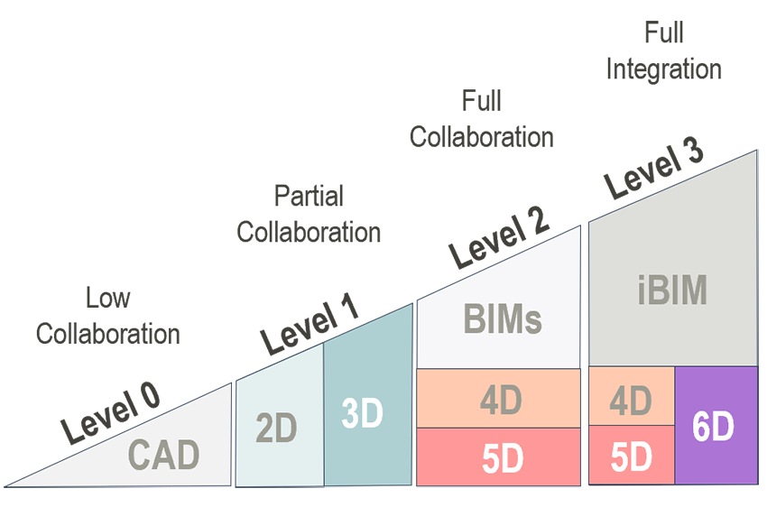
Figure 4.3.2.1 Maturity levels of BIM and BIM dimensions
Digital Twin
The term "digital twin" describes the "digital assets", i.e. the models or documents that represent a real, physical object throughout its lifecycle or at certain stages of its lifecycle. In the “BIM industry” (construction), a digital twin usually refers to a 3D geometric model of a building or bridge with all relevant attributes that represents and reacts to the real, physical twin, i.e., the real building or bridge, and may also generate certain reactions and changes in the real object. There can be a connection between the real twin and the digital twin. This connection can be either one-way or two-way (in both directions). Moreover, the connection can be either synchronous or asynchronous, depending on the so-called "coupling level".
CDE - Common Data Environment
The common data environment (CDE) is the central data repository required to perform the BIM Level 2 information sharing function. The CDE collects, manages and distributes relevant validated digital information about a built asset during the life cycle for multidisciplinary teams at the specified access level.
The CDE platform is generally hosted on an external server which is accessible to all parties involved in the in the design, construction and operation of the asset with the appropriate permissions. The CDE platforms have an automated information flow. Additionally, they use predefined ways of sharing, accepting and commenting digital information.
IFC - Industry Foundation Class
The Industry Foundation Class (IFC) is an open data format developed by buildingSMART for the information exchange and coordination between different process participants. The main advantage of such a format is its openness. Thus, it is possible to use it by software off different vendors (interoperability). IFC files contain all relevant object data such as geometry, location in space, individual elements data, element attributes.
buildingSMART
buildingSMART is an international organization aiming to promote the exchange of interoperable, open and non-proprietary data between software applications used within the construction industry. buildingSMART is involved in the development of IFC.
Level Of Detail
The level of detail (LOD) refers to the geometric content of the model and is used to define the required graphic content of the model at a particular stage of the project. As the project progresses, the components in the model will be delivered in more detail. For example, in the case of road design, one starts only with the gradient and the width of the road core to estimate the soil volumes. In the progress of the project, the cross slopes, geometry of the ditches and the layers of the road pavement are considered.
Level of Information
The level of information (LOI) determines the non-geometrical content of the model at certain stages of the asset. As the life of the asset progresses, the non-geometrical details increase. At the beginning, the pavement is represented as a purely geometric, spatial figure with individual pavement layers. As the project progresses, data on the individual layers is added, such as the construction material as well as detailed information on laboratory results. Later, in the operational phase, the bearing capacity of the overall structure and other condition data for the surface layer, such as skid resistance, are included.
Level of Model Definition
The level of model definition (LOMD) is the combination of LOD and LOI and defines the details required in a model at different stages of the project, both graphical and non-graphical. The client (owner, employer, customer) determines the level of detail required and documents it in the Exchange Information Requirements (EIR).
Despite the high level of awareness and acceptance of BIM applications in the construction industry, there is a conviction that the potential of BIM is not being sufficiently exploited. 64% of respondents who were asked about the biggest obstacles to the use of BIM give in the first place the lack of requirements by the client (NBS, 2019). This lack of requirements by clients for the implementation of BIM is particularly noticeable in infrastructure investments, including road construction.
The one-sided focus of BIM on planning and construction and at the same time the neglect of operations is one of the greatest weaknesses of the current orientation of BIM. This is also one of the reasons why BIM is so weakly spread among the owners and operators of horizontal infrastructure. This weak support for the operational phase and the network-orientation overlooks that investment costs during operation phase of the lifecycle represent 90% of total life cycle costs, while design and planning costs amount to only 1% (see Figure 4.3.3.1 - based on (NZ-BIM, 2019).

Figure 4.3.3.1 Infrastructure lifecycle phases and cumulative costs (based on (NZ-BIM, 2019))
The relationships between life cycle costs during the delivery and operational phases may differ from those stated above in the case of other asset classes.
With the support from the British government in the 1990s BIM solutions were developed including a landmark standard that was issued as UK: BS 1192:2007 (Collaborative production of architectural, engineering and construction information - code of practice) (BS 2007). This standard regulated the general principles of information management in the construction sector.
In the year 2018 ISO decided to adapt two British standards, which have become widely used worldwide: BS 1192-1 (concepts and principles) and PAS 1192-2 (delivery phase of assets). In addition, two other British standards PAS 1192-3 (operational phase of assets) and PAS 1192-5 (data security) have been incorporated into ISO international codes.
The international series of standards ISO 19650 already defines its field of action as information management in its title. It also considers information management as a "derivative" of Asset Management (ISO 55000) and organizational quality management (ISO 9001). These connections are shown in simplified form in Figure 4.3.3.2.
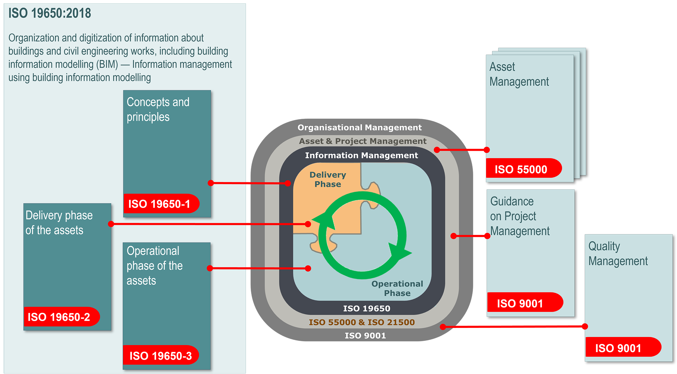
Figure 4.3.3.2 BIM-Standards and the Environment of other management norms
The ISO 19650 series of BIM standards are written in very general terms and do focus on specifics of BIM as solutions always depend on the context of the particular organization. However, through the reference in ISO 19650 to the Asset Management (as defined in ISO 55000), it is possible to derive the practical solutions and to implement the appropriate procedures.
The basic principles linking BIM with transportation asset management are outlined in the following paragraphs.
Orientation towards the relevant international standards
To promote sustainable solutions, the international standards are strictly referred to, especially the series of ISO 19650 norms as well as ISO 55000 (Asset Management). Where other relevant international standards are not available, reference is made to other recognized British standards, e.g. BS 8536 (GSL - Government Soft Landings) (UK BIM Framework).
Perspective of the specific organization
A fundamental role in BIM is played by the organization, i.e. the respective road administration (e.g. central or local road administration, municipal administration, etc.). All processes are developed and implemented from the perspective of the organization, its objectives and considering the unique organizational context. Thus, the interests of the owner, operator, or concessionaire are always at the forefront.
Compatibility with Asset Management
Asset Management, with its focus on the particular organization and its objectives, and on the entire road network or in many cases the whole asset portfolio, is the cornerstone of BIM in the road administration.
Special features of BIM for horizontal infrastructure
In order for BIM to be more widely used for horizontal infrastructure, BIM should take the owner's perspective and view the entire asset system as an asset portfolio, as required by asset management in accordance with ISO 55000.
BIM defines two main phases in the life of any technical object: the delivery phase and the operation phase. The delivery phase includes planning, designing, construction of the new object, but also all other building activities in the lifecycle, such as maintenance and rehabilitation. The activities in the delivery phase are usually performed by appointed contractor(s). The delivery and operational phases interrelated in that an asset is design and commissioned, it then goes through a phase of maintenance and rehabilitation and at this end of its functional life, it may be reconstructed, then repeating the maintenance and rehabilitation.
BIM supports the road asset manager by providing the information models for both lifecycle phases, namely Project Information Model (PIM) for the delivery phase followed by Asset Information Model (AIM) for the operational phase (see Figure 4.3.4.1).
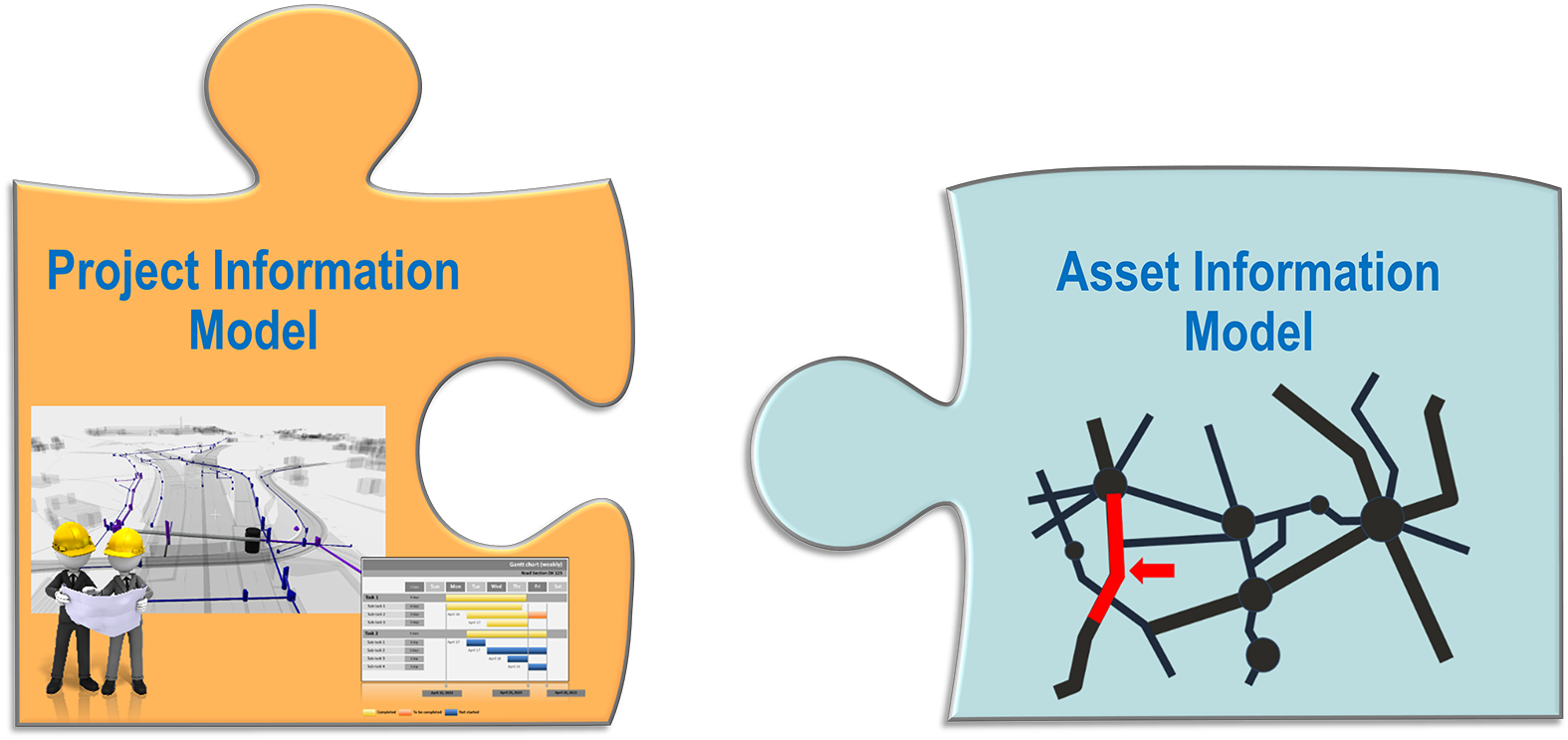
Figure 4.3.4.1 Interconnection between the network-oriented Asset Information Model and the measures-oriented Project Information Model
BIM according to ISO 19650 formulates uniform requirements for the information that is generated and managed in both lifecycle phases. These requirements are collected in a set of documents that support the asset manager (owner and operator) throughout the entire process of Asset Management. The two kinds of Information Models (AIM and PIM) and the documents containing the information requirements are the crucial pillars of BIM in the organization.
Figure 4.3.4.2 schematically shows the two main phases in the asset lifecycle with the corresponding information models and the most relevant trigger events (from "A" to "E").
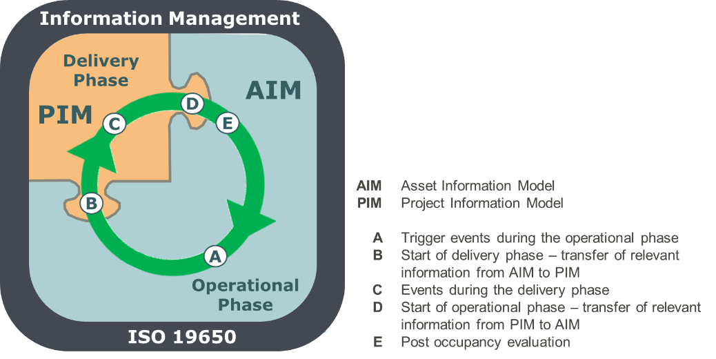
Figure 4.3.4.2 Control loop of information and the relevant phases of the life cycle (based on ISO 19650-2 and ISO 19650-3 (ISO 2018))
The Asset Information Model covers the entire road network or asset portfolio under the jurisdiction of the respective road administration. The road database manages data and information to support ongoing operations as well as the planning of construction activities. As a rule, the road network model, the axis geometry, the cross-section elements, construction data, maintenance history, road equipment data, traffic data and, depending on their availability, other data such as bridges and tunnels, pavement and bridge condition data, images, accident reporting information, etc. are managed in this database. In addition to the standardized information in the road database, the Asset Information Model also includes other information, sometimes in distributed data sets or as "data containers" that may be integrated into decision-making processes as required.
The relevant tasks of the operator include the planning of routine operations (summer and winter operations) as well as planning construction and maintenance activities supported by Pavement Management Systems or network resilience analysis. The reporting on the inventory and condition of the entire network as well as the provision of relevant KPIs and other information for the owner and the general public are also based on the data from the Asset Information Model (see item "A" in Figure 4.3.4.2). These activities address the entire road network managed by the operator.
For pragmatic reasons, the Asset Information Model will not address the requirements for geometric accuracy (LOD) that are common in the planning and construction phases. In the operational phase, a focus on high LOD would be counterproductive because 3D models as applied to the delivery phase do not add value for many use cases, such as winter maintenance planning or prioritization of road sections for maintenance. The ISO 19650 standard emphasizes at several places that the Level of Model Definition (LOMD) must always correspond to the actual tasks and practical requirements.
Planning of maintenance and rehabilitation activities are regularly performed on the entire road network. It is in the operator's best interest that the changes of the as-built data resulting from the construction work are reflected in the Asset Information Model. One of the prerequisites for correctly updating the Asset Information Model partly already during or at the latest directly after the execution of the construction measure is providing the contractor with the current inventory data for the particular network element from the AIM (see item "B" in Figure 4.3.4.2).
Information management during the execution of construction activities is supported by the requirements outlined in the EIR (Exchange Information Requirements) and in the BIP (BIM Implementation Plan). The plan defines how the exchange of information between all parties will take place and how Common Data Environment will be developed.
The Project Information Model defined for the duration of the project determines both the data model (the digital twin of the construction object) and all data management processes. Effective information management and the exchange of information must be ensured (see item "C" in Figure 4.3.4.2). For larger projects with high realization costs and involvement of multiple parties, complex 3D data models will be applied. However, for small-scale projects, simple models are usually adequate.
Once construction activities are completed, the information is transferred from the Project Information Model to the Asset Information Model (see item "D" in Figure 4.3.4.2). The transfer is done in accordance with the requirements that are formulated in advance, during the needs assessment and documented as the Asset Information Requirements (AIR). Regardless of the scope and complexity of the specific project, it is relevant that all information about the completed project is coded according to the Asset Information Model standard. The information is transmitted either through the interface provided by the operator or through reconciled data services and controlled by the operator before the final update of the AIM (see item "E" in Figure 4.3.4.2). If the project has been implemented according to the highest level of BIM, it is recommended that the operator deliver the complete model (e.g. as an IFC model) in a data container and additionally extracts the data required by AIR from the PIM in the desired convention.
If all construction projects were performed according to the above-mentioned BIM requirements, a systematic update of the AIM and an increase in efficiency in the operational phase is achieved.
The construction projects carried out in the BIM standard differ from the traditional projects in that there are always two separate deliverables: one for the physical object, such as a modernized bridge or a renewed pavement, and the second proving standardized information describing these objects.
This second deliverable is the subject of modeling and should be provided according to specified rules in order to meet the objectives of the agency or operator. The complexity of the information should correspond to the scale of the particular project and reflect the strategic asset management objectives of the specific organization. To support the asset manager in formulating the information requirements ISO 19650 recommends that these requirements be grouped into a series of separate but linked, partially hierarchical documents.
ISO 19650 does not provide a blueprint for all these documents because they must always be consistent with the context of particular organization and should consider it size, maturity level and the need for the specific service.
Five most relevant BIM documents (see Figure 4.3.5.1) with information requirements have been briefly described below.
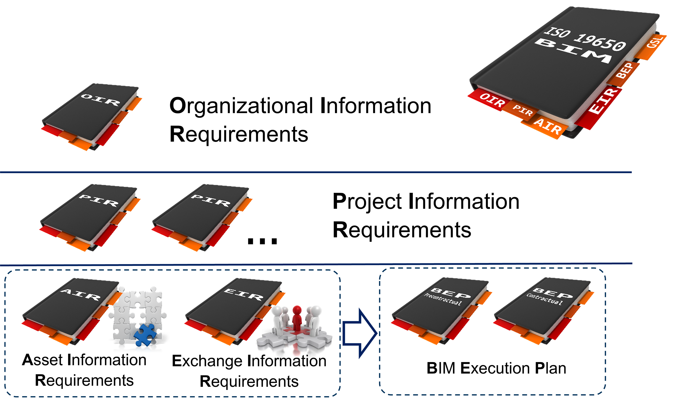
Figure 4.3.5.1 Most relevant documents for the information management in the organization
The most important document is called Organizational Information Requirements (OIR) and formulates the requirements resulting from the strategic goals of the organization and from the Asset Management System. The precondition for specifying these requirements is the identification of tasks to be performed by the relevant organizational units. In order to fulfil these tasks, information of a certain, task-specific quality is required, i.e. of a specific accuracy, completeness, timeliness, etc.
Each organization needs information for strategic tasks for the financial planning of investments (i.e. annual or multi-annual construction program) and for operational obligations. Some information also needs to be shared with external stakeholders, such as the local governments, the public, financial institutions and insurance companies. The detailed information regarding the asset construction measures assists in documenting the suitability of the construction materials and technologies, provides the basis for the pavement quality and for the development of prediction models. The general rules for determining the requirements for the information collected and managed, for its quality, level of detail, reference systems, etc. are the content of the OIR.
In modern road administrations, ensuring the flow of information in the required quality is as important as ensuring the availability of material and financial resources. Therefore, the necessary processes must be defined and procedures (such as regular pavement condition surveys) or tools (such as a road database) must be provided.
The Organizational Information Requirements establishes framework that apply to all other types of information requirements and are considered critical for BIM in an organization.
All transportation assets will require maintenance and rehabilitation measures to maintain the desired level of service. These projects are always associated with information that is collected, exchanged, transferred, updated, assessed, evaluated, etc. ISO 19650 recommends that the general requirements for information generated in connection with the realization of the projects of certain types are well documented in the Project Information Requirements (PIR).
Both documents, OIR and PIR, are internal documents of the organization. As OIR affects the work of all administrative units, it must be disseminated throughout the organization. Personnel responsible for tendering and supervising projects must be aware of PIR.
Asset Information Requirements (AIR) contain the OIR-derived requirements relate to the operational phase of the asset and are directed to the service providers, i.e., primarily the companies contracted to design and implement the construction projects. In the control loop of the information flow between the two phases shown in Figure 5, the transfer of information from the PIM to the AIM after project completion plays a fundamental role (see item "D" in Figure 4.3.4.2). Typically, this is the place/time where most of the information losses occur. Therefore, appropriate requirements for the information content, the process of information exchange and even the responsibilities and qualifications of the groups involved in this process must be formulated already in the phase or requirement setting.
AIR are closely related to the Government Soft Landings (GSL), which plays an important role in the "smooth" transition from the delivery phase to the operation phase. In order to ensure a GSL after completion of the construction project, a separate guideline has been issued.
Unlike the Asset Information Requirements, which refer to the phase of operation after the completion of the project, the requirements in the Exchange Information Requirements (EIR) are oriented to the delivery phase of a specific project. The document contains requirements necessary for an efficient exchange of information between the parties involved in the project in order to provide the contracting authority with answers to its business questions related to the procured investment project.
To ensure the required efficiency and quality of information exchange, EIR may require certain types of modeling of the assets involved and may also prescribe the procedures and tools to be employed. For example, modeling may be required to be performed according to specific LOD.
The two last documents - AIR and EIR - refer to the specific project and will be published during the tendering process.
Based on the EIR and AIR documents, the tenderer is requested to submit a BIM - Implementation Plan (BIP). The BIM Implementation Plan is the basic BIM document during the construction process. It describes the proposed manner of implementing the requirements formulated in the EIR and AIR and specified the details of the Common Data Environment (CDE).
Depending on the modalities of the tender, there can be two BEP versions: a pre-contractual version (offered BEP) and a contractual BEP.
Structured information management assists the asset manager to optimize the overall asset management goals. The ISO 19650 standards, by positioning BIM in a direct environment of Asset Management and by showing the mutual relations, have given considerable impetus and incentive for the adoption of asset management systems by the road infrastructure owner and operator. Figure 4.3.6.1 shows the relationship between the information generated through the asset management system and BIM, how they are generated, and how they are connected (Miskimmin).
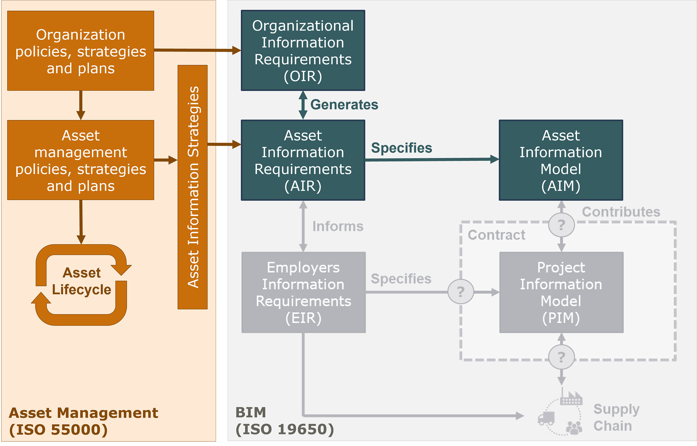
Figure 4.3.6.1 Relationship between Information generated in Asset Management and BIM (on the basis of Miskimmin)
It is certain that BIM will continue to be one of the most dynamically developing disciplines. This is definitely true for the technical BIM-solutions and hopefully also for the management solutions in the organizational environment of Asset Management.
BIM for all phases of lifecycle
Although the BIM methodology requires that the entire lifecycle of a given asset must be considered, the overwhelming majority of practical applications of BIM are still limited to design and construction. While for most building construction objects such an approach may be justified and rational, the asset manager of horizontal infrastructure, such roads, when planning the new construction, upgrading or renewal of a road, usually has to consider the subsequent actions within a road section, i.e. the repair or renewal actions resulting from the scenario provided by the Pavement Management System. Thus, this 4th dimension of BIM, that is time, is of particular importance for road infrastructure and should be extended to the whole life of the road section.
BIM for entire Asset Portfolio
The specific nature of transportation investments puts an additional, very important requirement on BIM. The coordination of construction plans by managers of different infrastructure systems responsible for the entire infrastructure portfolio is necessary, but this is a major challenge due to the frequent lack of organizational structures dedicated to the coordination of such tasks. The need to consider the entire infrastructure portfolio does not mean that every BIM project is burdened with further constraints and restrictions. However, the infrastructure manager must be aware of these realities and take them into account both in the formulation of the Asset Management Strategy by itself and in the requirements for individual BIM projects.
Continuing education of BIM professionals
One of the challenges in implementing BIM in the road sector is overcoming barriers and the lack of awareness among managers in road administrations regarding the benefits that targeted application of the discipline's methods will bring to them. This is confirmed by numerous surveys and polls. Considering BIM only as a tool for 3D modeling that supports the designer makes it very difficult to promote BIM as a management method.
Therefore, educational activities to disseminate and promote BIM and to raise awareness of its importance in the context of information management will play an increasingly important role. The broader the knowledge of the possibilities of BIM applications according to ISO 19650 among asset managers, the greater likelihood that managers will demand the development and implementation of BIM procedures.
Over time, two BIM streams have emerged. One stream is oriented towards optimizing the planning and construction phase of individual projects. The principle of this stream is: first build digitally and only then build for real. The addressees are the planning and construction companies. This BIM stream is mostly associated with 3D modeling.
The second BIM stream is oriented towards the entire road network and the primary addressees are the owners and operators of the infrastructure. The mission is to support broad digitalization in order to optimize the main objectives of the infrastructure owner. So, the message is addressed to the owner and operator and reads: keep control over your network data to optimize your goals. The main reference source of this second BIM stream is ISO 19650.
The appropriate implementation of BIM by the operator for all construction activities can lead to a breakthrough in digitalization in the road construction sector. The implementation of BIM in the road administration of the operators will also contribute to a better use of the information already managed in road databases. The simple existence of information and its availability is not enough. Only the transformation of information into knowledge, by making it available to the stakeholders involved and by a targeted exchange between all parties involved in engineering activities and decision-making processes, gives this information a real, tangible value. The result will be an increase in the quality and efficiency of the work, an increase in the agency’s rank and reputation, and an increase in the satisfaction of its employees.
In this chapter practical examples from Germany are used to show how the procedures of BIM according to ISO 19650 are applied for the systematic acquisition and provision of pavement condition data.
The ISO 19650 standard is written in a very general and partly abstract way. This is to ensure that the rules and best practices for information management can be applied as widely as possible. For practical application, however, adaptation to the specific features of the respective type of infrastructure is essential. Only then could practical benefits be derived from the application of the standard. Such adaptations and "translations" of the general rules, which are often formulated abstractly in the standard, into the "language" of the respective professional discipline are necessary in order to exploit the benefits of the ISO 19650 standard for the respective professional discipline.
At this point, it is important to emphasize that BIM, as interpreted by the ISO 19650 standard, is primarily focused on the acquisition and exchange of information relating to construction objects. Professional aspects such as design techniques or construction technologies are of course always important, but only to describe the general framework within which information management is performed. Furthermore, it must be clearly stressed that information management (like any management) is always situated in an organizational context. The goals of the respective organization, in this case the owner or operator of the road infrastructure, and the strategies and tasks derived from these goals determine the framework in which information management is practiced. For this reason, this chapter always refers to the respective general framework that determines the organization's actions, i.e., the organizational or professional context. This is to show that different solutions may be optimal in different circumstances.
In all construction activities, on the one hand physical objects are created or changed (e.g., structures are modernized) and, on the other hand, information is generated and exchanged that is necessary for the target-oriented execution of these construction activities. This information is essential for the operator, both during the construction phase and especially after commissioning of the completed construction object.
While the requirements for the technical tasks are formulated in the relevant professional standards, the BIM standard ISO 19650 formulates requirements for information management to achieve the goals of the construction project and to support its subsequent operation. The application of ISO 19650 is particularly useful in the case of multiple project participants. Experience shows that good information management has a positive effect on the efficiency of the actual project activities on the one hand, and on the other hand enables a smooth transition from the project phase to the operational phase after completion of the construction work.
Projects in which information management plays a key role include projects for the network-wide monitoring and evaluation, such as pavement condition data. Therefore, the execution of the projects for the pavement condition acquisition in accordance with ISO 19650 provides many benefits.
The German System for the monitoring and assessment of pavement condition ZEB (German abbreviation from Zustandserfassung und -bewertung) is based on the same established management rules as the British Standards series BS 1192:2007 (BS 2007). This standard was prepared with the aim of spreading digitalization to the entire construction industry. It was the first introduction of the then pioneering idea of a Common Data Environment (CDE). Since then, the CDE approach has been one of the most important features of all BIM-oriented construction projects.
Immediately after the publication of the British standard BS 1192, some of the ideas presented there were examined and validated in Germany with the aim of applying them in the framework of ZEB. In the same year of its publication (2007), the CDE concept was put into practice in a first pilot project for ZEB on state roads in Baden-Württemberg. Further BIM solutions were also successively adopted in the ZEB.
The most important principle of any information management in the organization is to acquire and manage data to the scope and quality required to support organizational goals. An abstract striving for the best quality of information without considering the current and planned scope of application contradicts not only the principles of modern Asset Management, but also elementary principles of economy.
When developing an information management strategy, it is therefore of fundamental importance to first identify the objectives and the resulting activities and tasks. Based on this, requirements must be defined for the information that contributes optimally to supporting these tasks and thus indirectly to achieving the company's goals (see Figure 4.3.7.3.1).
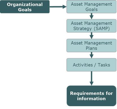
Figure 4.3.7.3.1 Requirements for the information are derived from the respective tasks
The organization's strategy for streamlined information management and the derivation of information requirements from the organization's goals, strategies, and plans are captured in the key BIM document, referred to in the ISO 19650 standard as Organizational Information Requirements (OIR).
Information about infrastructure represents a valuable asset and should be treated like other assets. The quality standard for the acquisition, evaluation and management of information should therefore be determined according to general economic principles. This involves comparing the benefits of using the information in the decision-making process with the costs of obtaining the information. The methodological basis for such consideration is provided by the discipline of Infonomics (Laney, 2017).
In this chapter, the terms "data" and "information" are often used interchangeably, although information management sees a clear difference. Data are the direct result of measurement or other survey and contain, for example, the elevation points of a roughness profile at 10cm intervals. They are often referred to as "raw data". By specific assessments, such raw data can be used to determine e.g. the IRI (International Roughness Index) for longer sections (e.g. of 100m), which are already considered as information, since these values can be used in decision-making processes. However, as long as the integration of the information into decision-making processes is hampered, e.g. because the access to the information is restricted or the form of presentation does not meet the expectations of the addressees, the benefit of such information is low or non-existent. Only when the information flows into decision-making processes and can have a positive impact on the goals of the organization will it reach the highest "evolutionary level", namely knowledge (see the so-called Knowledge Pyramid in Figure 4.3.7.3.2).
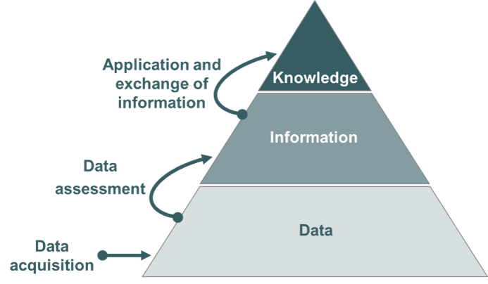
Figure 4.3.7.3.2 Knowledge Pyramid
For pragmatic reasons and also because of the technical terms already established in the road sector, the term "condition data" is usually used here, even when it is clearly "condition information".
Pavement condition data is used at all levels of Road Asset Management. Some selected applications of pavement condition data at the strategic, tactical, and operational management levels of road maintenance management are listed below.
Strategic management level:
• Determining medium and long-term maintenance needs in order to achieve specific quality objectives (measured by pavement condition),
• Ensuring horizontal (between sub-networks) and vertical (between sub-networks of different road classes) network consistency in the medium and long term, thus ensuring equivalent traffic performance in the overall network of the operators,
• Analyses of the performance (robustness) of construction technologies and materials based on the monitoring of the evolution of pavement conditions in the respective networks or sub-networks,
• Identification of Key Performance Indicators (KPI) for planning purposes and for the owner's bodies,
• …
Tactical management level:
• Allocation of maintenance funds to regional authorities to meet political and socio-economic demands and to achieve the desired level of disparity,
• Development of the short- and medium-term maintenance programs (localization of the maintenance measures) within the available budget,
• Controlling of the maintenance programs,
• …
Operational management level:
• Identification of the sources of damages,
• Determination of the appropriate type of measures for the planned maintenance programs,
• Early detection of unfavorable condition development,
• …
However, the pavement condition data is also used for numerous other tasks that go far beyond maintenance management. These include, for example, traffic safety analysis, including the calculation of safety potentials and support for safety audits. Geometry data, such as longitudinal slope and curvature, collected over a wide area during the pavement condition monitoring process are used for network-wide traffic engineering and economic analyses. In addition, route images routinely created during condition surveys are used for a variety of tasks, including for inventory purposes.
To ensure that the pavement condition data is suitable for the above-mentioned applications, it must permanently meet certain requirements.
The following three roles are always foreseen among the actors in the pavement condition monitoring and evaluation projects:
The most important requirements for the system for monitoring the pavement condition data include (Heller, 2011):
Standardization of data and processes
All processes of data monitoring and assessment must be kept stable over a longer period of time in order to ensure one of the most important requirements, namely the comparability of the condition data over time. This comparability over time is crucial, among other things, for the generation of prognosis models. At the same time, it must also be possible to compare the data between the administrations (between the sub-networks). Such spatial comparability is, in turn, a prerequisite for achieving the envisaged network consistency, which is an important strategic goal from the perspective of a road network owner's. Since pavement condition has a significant impact on driving comfort and safety, it is considered an important factor for this network consistency. In addition, the quality of the condition data must be ensured according to clear and standardized criteria in order to guarantee the comparability of the results of the pavement condition studies.
These requirements can only be met if the entire process for monitoring and assessment of the pavement condition data is standardized. In Germany, the ZTV-ZEB-StB (FGSV, 2006) represent such a standard.
Task-neutral monitoring and task-oriented assessment of pavement condition data
The ultimate result of the pavement condition monitoring is georeferenced raw data, so-called GEO raw data, in high resolution. They are delivered in files in defined and documented formats. Figure 4.3.7.5.1 shows a section of a GEO raw data file with longitudinal evenness data. The GEO raw data also includes the georeferenced route images as well as the high-resolution surface images, which provide the basis for the manual or automatic detection of surface properties in the later assessment phase.
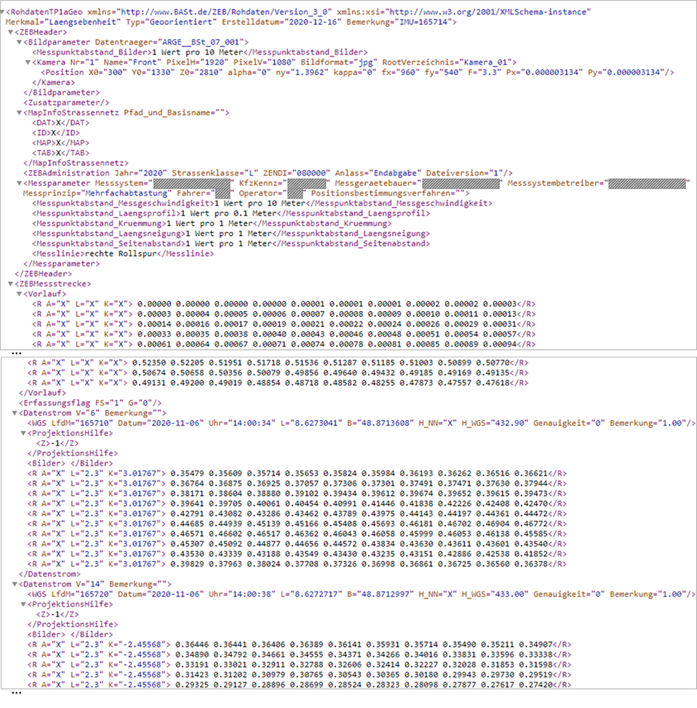
Figure 4.3.7.5.1 Fragment of a GEO raw data file with longitudinal evenness data
In GEO raw data, the entire data stream is typically referenced every 10 meters to a point whose location is uniquely determined by geographic coordinates.
For practical purposes, these GEO raw data must be assigned onto the network, i.e. onto the linear referencing system. Because the projection is done on the road axis and because of the inaccuracies in the recording of the coordinates, the raw data stream must be stretched or compressed accordingly. Since different methods can be used, the process of data projection is standardized and a freeware standard software (GEO-ROH-RASTER) is provided for these purposes by the federal authorities BASt (German Federal Highway Research Institute).
The GEO raw data projected onto the road network are aggregated in the data segments of an evaluation raster. One data segment of the raster corresponds to the ZEB evaluation sections of 100m in non-urban areas and 20m in urban crossings and is uniquely localized by means of the kilometers of the beginning and the end as well as by the indication of the traffic lane. All localization information must correspond to the current network model in the Asset Information Model (AIM).
The RASTER raw data generated in this way provided the basis for the computation of the pavement condition quantities and values, as well as for the visualization of the raw data, as shown on Figure 4.3.7.5.2.
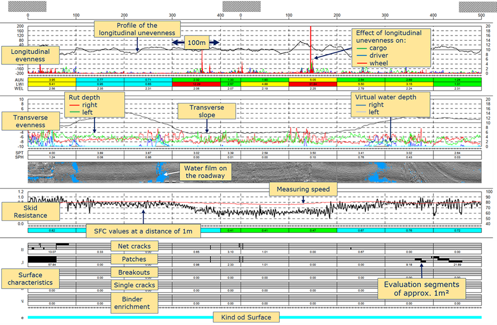
Figure 4.3.7.5.2 Example of a profile with RASTER raw data for the purposes of the operational tasks
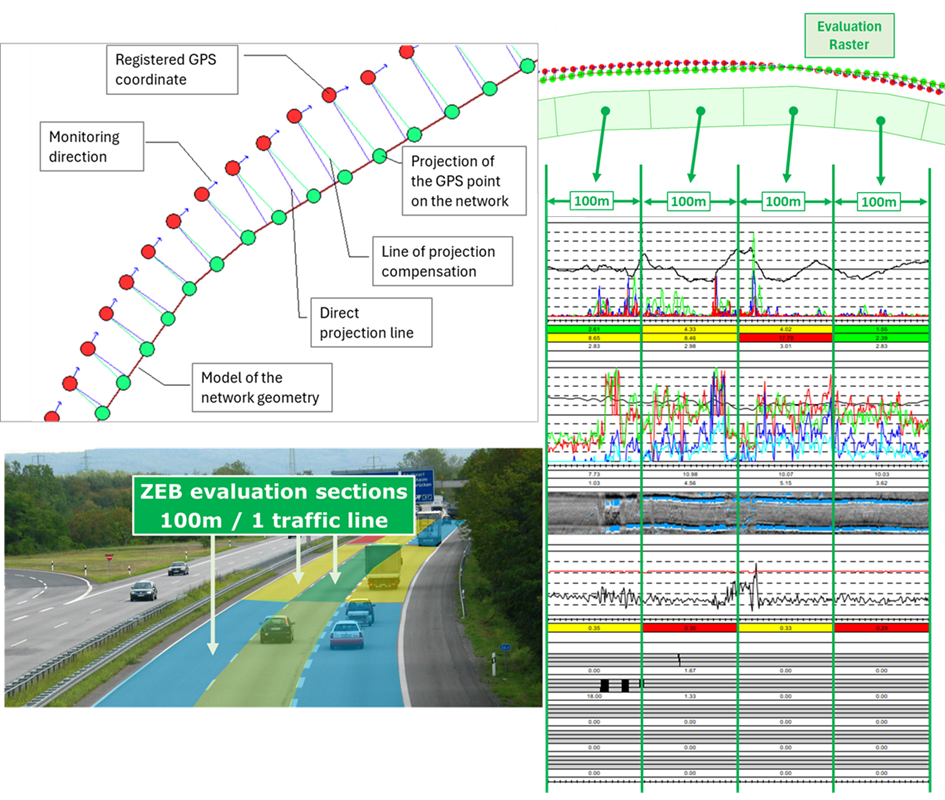
Figure 4.3.7.5.3 schematically illustrates the process of projecting GEO raw data onto the geometry model of the network to create the RASTER raw data.
The GEO raw data is the basis for further assessments:
Figure 4.3.7.5.4 shows the major standardized assessment steps of the pavement data.
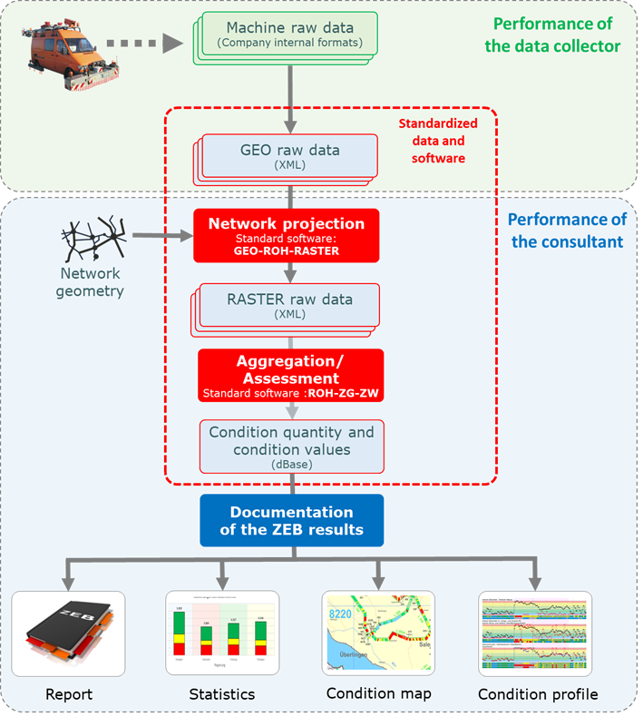
Figure 4.3.7.5.4 Standardized assessment steps of the pavement condition data
If, due to new research insights, the algorithms for determining the condition parameters change or new or alternative characteristics are defined, it is always possible to assess the historical GEO raw data from the previous ZEB projects according to the new algorithms and thus validate the object- and network-related consequences of such modifications.
The raw data also provide the basis for a wide range of applications, including those that were not known at the time of the survey. This high degree of flexibility is achieved by making the monitoring process somewhat 'task neutral', by giving the raw data the status of an ultimate data source and by standardizing its format.
In this way, the raw data can be used as a basis for further assessments that go over and above maintenance planning. For example, skid resistance data aggregated to 100m are of limited value for object-based analyses of traffic safety. Therefore, the indicators are calculated based on the moving average of 1-m measurement results, which are then linked to geometry data such as curvature. This allows areas with road safety gaps to be identified much more accurately and targeted.
In the meantime, there are also numerous other applications for the pavement condition data beyond road administration that benefit from the availability of the raw data, e.g. in the automotive industry. Even the route images recorded as part of ZEB, which were originally used only to check the plausibility of the condition data, are now being applied massively for various other purposes. The fact that these images are available network-wide in the same resolution and the required quality makes them a good basis for comprehensive photogrammetric assessments.
Efficient providing of the condition data and assessment results
As mentioned above, the real value of condition data and information is determined by their impact on specific decision-making processes . Providing the condition data in a suitable aggregation level and presenting or visualizing it in a suitable form are therefore of fundamental importance. As a result of ZEB, statistical assessments and visualizations in the form of diagrams, maps and profiles are thus provided in addition to the pure condition data (raw data, condition quantities and condition values as well as road or surface images). The raw data are also presented in a corresponding form on so-called raw data profiles (see Figure 4.3.7.5.2).
Since the spread of online technologies, it is expected that all relevant data and results are also available online for authorized users.
Sustainability
The described ZEB procedure was first introduced by the federal government in the early 1990s for the federal motorways. In the meantime, it is used by all German federal states and by many counties and cities. Even though the scope and procedure of the evaluation procedures are often adapted to the local circumstances in the individual federal states or counties, which is made possible by the principle of task-based assessment, the general approach of ZEB must remain unchanged over the years.
In order to ensure the long-term comparability of the results despite the shareholding of different actors, the BASt has commissioned the development of special software for all relevant evaluation steps, which is made available free of charge to all companies involved in ZEB projects. The software is continuously maintained and kept up to date.
All pavement condition data and information are affected by a life cycle. They are either in the phase of acquisition, i.e. monitoring and assessment within the framework of a ZEB project, or in the phase of utilization or application.
These two phases of the life cycle of the condition data are closely related to the life cycle of the road infrastructure. In accordance with the terminology of the ISO 19650 standard, the two phases mentioned above can be referred to as the delivery phase (providing the condition data for use in the operational phase) and the operational phase.
The data model of condition data at the delivery phase is called in ISO 19650 the Project Information Model (PIM). In the subsequent operational phase, the condition data are part of the digital model of the entire road infrastructure, i.e. the Asset Information Model (AIM).
Since the pavement condition changes continuously, the condition data must also be updated periodically (see Figure 4.3.7.6.1). The distinctive events (according to the ISO 19650 standard), such as the transition from the operational phase to the delivery phase (B), are also shown in this figure. The index indicates which ZEB project is concerned. The explanations of these distinctive events can be found in the further part of the present document.
As a rule, the ZEB project is repeated every 4 years. During the delivery phase (ZEB project), the current condition data from the road infrastructure Asset Information Model are still used. Directly after, the updated condition data is transferred to the Asset Information Model and the previous condition data is historicized for use in analyzing condition changes.
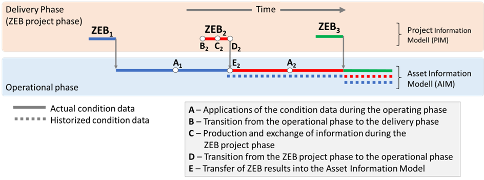
Figure 4.3.7.6.1 Life cycles of the pavement condition data (the distinctive events A-E are explained in Figure 4.3.7.6.2)
This permanent change between the phases of delivering and operating is represented in ISO 19650 as a control loop of information (see Figure 4.3.7.6.2). The distinctive events (based on ISO 2018) / activities (A to E) are described below.
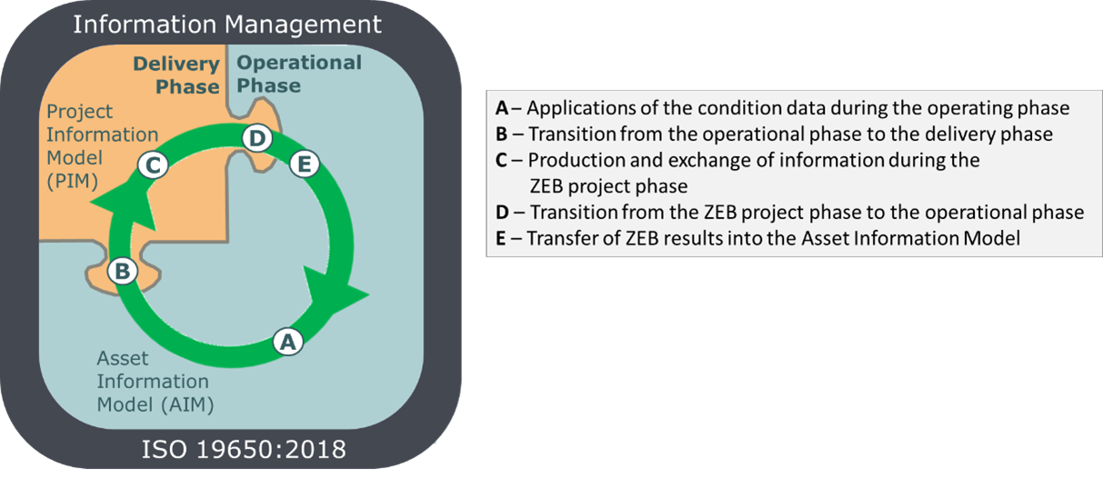
Figure 4.3.7.6.2 General representation of the control loop of information with distinctive events (based on ISO 2018)
A - Applications of the condition data during the operating phase
In the operational phase, the network-wide condition data are used for numerous tasks at all decision-making levels. Some examples of such tasks are given in Chapter 4.3.7.4. In most cases, the condition data integrated in the digital model of the network, i.e., the Asset Information Model (AIM), is used. However, some special applications require raw data or special indicators that are not available in the AIM. In such cases, appropriate professional systems are used.
B - Transition from the operational phase to the delivery phase
Event (trigger) "B" in the control loop of condition information refers to the initialization of a ZEB project. The client (usually the operator of the road network) formulates the requirements for the results of the pavement condition monitoring and assessment. These requirements cover the formats of the GEO raw data as well as the formats of the result files and the files with images. In ISO 19650, these requirements are referred to as Asset Information Requirements (AIR). Meeting these requirements ensures that updated condition data can be imported directly into the operator's Asset Information Model after finishing the ZEB project.
In addition, requirements are formulated for the entire monitoring process, for quality control, for data exchange between the actors, and for data provision, including deadlines for all milestones scheduled in the project. These requirements are referred to in ISO 19650 as Exchange Information Requirements (EIR).
Both groups of requirements, i.e. Asset Information Requirements and Exchange Information Requirements, are components of the tender documents.
Within the framework of a tendering procedure, the client selects one or more contractors to be commissioned with monitoring (data collector) and one consultant, who is independent of the data collectors. The consultant's tasks correspond to those of the BIM coordinator, but go beyond this and extend to professional activities.
One of the consultant's tasks is to set up and operate an IT system that serves as a Common Data Environment (CDE) on the one hand and is equipped with advanced modules for assessment and other analysis on the other. The general requirements for the functionality of the CDE in all phases of the ZEB project are formulated in the respective tender documents. They comply with ISO 19650's BIM Implementation Plan (BIP).
In addition to the classic tasks of a BIM coordinator, the consultant has to fulfill a number of professional tasks, which are particularly related to quality management. These tasks include, among others:
C - Production and exchange of information during the ZEB project phase
The ZEB project is characterized by a very high level of complexity. Large amounts of data and information are exchanged between the involved actors and along the interfaces between the realization phases. Any disturbances in this exchange of information at these interfaces would have a negative impact on the efficiency of the entire ZEB project and cause delays in the delivery of condition data, which in turn would have a negative impact on the routine tasks of the operators and owners.
For this reason, the client formulates strict requirements in the document - EIR (Exchange Information Requirements) for meeting the deadlines for the individual milestones and for the quality of the data and results. The three objectives are followed:
Although the ZEB projects have already been implemented for several years using the same procedures and one might think that they have therefore reached routine status, the complexity of the project and the numerous risks indicate that a high degree of flexibility is also required in the design of the entire approach.
The prerequisite for meeting these demanding requirements for ZEB projects is the support of professionally qualified staff that understands the requirements of the client and acts accordingly, as well as the implementation and operation of an IT system with the CDE functionality and with other features for solving specialized tasks. The Customer formulates the requirements for the functionality of such IT system that will be applied throughout the project phase.
The OnKo system is used as the CDE platform for the ZEB in almost all ZEB projects in Germany. Since its first deployment in 2007, the CDE/OnKo platform has been used in ZEB-projects in Germany and abroad, managing condition data on a coverage length of more than 700 thousand lane kilometers only on federal highways and state roads.
D - Transition from the ZEB project phase to the operational phase
The ZEB project ends with the handover of all contractually agreed delivery objects, i.e. the GEO raw data files, the RASTER raw data files, the results files, the files with route and surface images as well as the documentation and visualization of the results by the consultant to the client. The amount of data is considerable. For example, a ZEB project for state roads in Baden-Württemberg in 2020 generates more than 8 terabytes of data.
E - Transfer of ZEB results into the Asset Information Model
Most of the digital models of the road infrastructure (Asset Information Model) of the federal states in Germany are limited to the management of aggregated data, i.e. the condition quantities and values for the individual evaluation sections (100m/20m). Often the road images are also included. The raw data are usually not included in these models.
Deviating from such approach, some federal states, including Baden-Württemberg, have decided to use the CDE/OnKo - platform not only during the ZEB project, but also after its completion as a supplement to the digital model of the road infrastructure (Asset Information Model). So OnKo takes on another role, no longer as a CDE - platform, which it played during the ZEB project, but as a specialized system for the assessment and providing of pavement condition data.
The GEO raw data managed on the OnKo platform meet the requirement: "Single Source of Information" and thus, as a continuation of the CDE in the ZEB project, represent the original source for all pavement condition indicators generated from the GEO raw data, in particular condition quantity and condition values. OnKo is also equipped with a WFS (Web Feature Services) to integrate the condition data and images into third-party applications. The geographic layers with the condition classes can be integrated into external GIS applications using WMS (Web Map Services).
Furthermore, OnKo has the functionality to project condition data from previous ZEB projects onto the current road network and thus realize so-called dynamic data evaluations. Figure 4.3.7.6.3 shows an example of such an assessment of the dynamics of pavement condition.
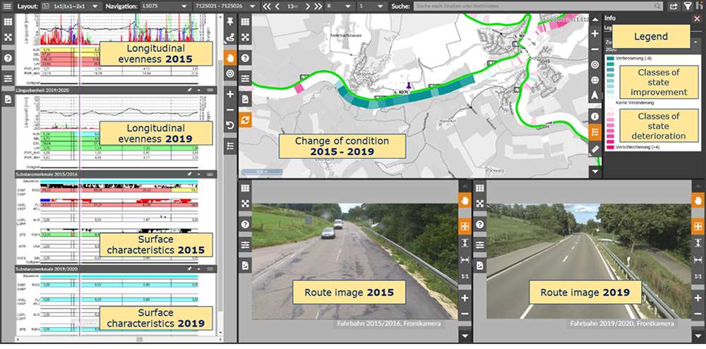
Figure 4.3.7.6.3 Example of professional analysis of pavement condition dynamics with OnKo-System (here: condition on a upgraded road section)
Although ZEB projects have been regularly performed in the area of federal trunk roads since 1992, and a few years later in the area of state roads as well, it took several years to establish a uniform IT solution to support these projects. This was triggered by the idea of a Common Data Environment presented in the British Standard BS 1192 in 2007. In the same year, the idea of a Common Data Environment as a platform for the exchange of information was realized using software within the framework of a ZEB project for the state roads in Baden-Württemberg and implemented throughout the entire network.
This data and information platform is used for the exchange of information and furthermore for the maintenance, quality control and assessment of the ZEB data in all its four "evolutionary stages": Work in Progress, Shared, Published and Archive (see Figure 4.3.7.7.1 (based on BS, 2007)).
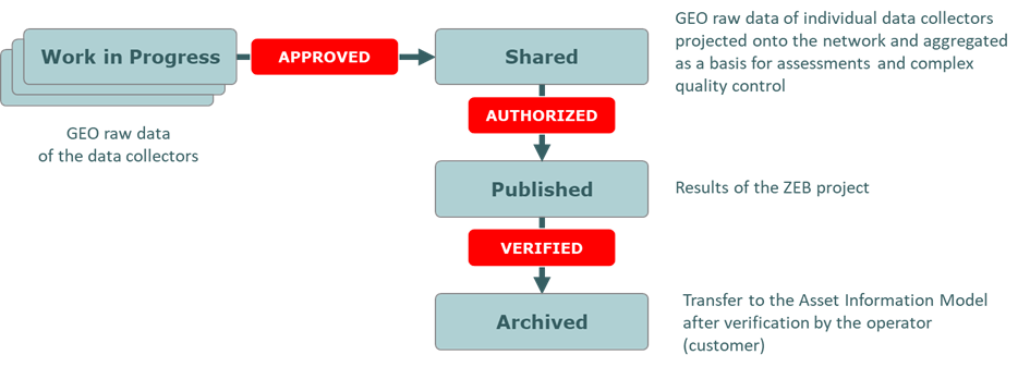
Figure 4.3.7.7.1 The "evolutionary stages" of information on CDE (based on (BS, 2007))
CDE/OnKo is also provided with functions for interactive and synchronized visualization of the pavement condition data. This enables the authorized stakeholders, especially the client and the consultant's team, to perform a complex control of the collected raw GEO data at the stage: Work in Progress and especially after their verification and aggregation at the stage Shared. For this purpose, a special visualization of both, the raw data and images was made available online, so that the client's on-site could also contribute to a better control of the data with their knowledge of the local circumstances. Their comments, especially the critical ones that could be entered online in fields provided for this purpose, contribute to the successive building of a knowledge base for the engineering assessment of the interpretation of the surface properties.
Currently, the CDE/OnKo platform is equipped with all the functions that support the consultant in all his specialized tasks, including the procedures for quality control and complex assessment and visualizations.
In the following, the main functions of the CDE/OnKo platform in the ZEB projects are listed.
Archive and knowledge base
On the CDE/OnKo platform, all relevant documents for the subject area of ZEB as well as for the respective ZEB project are made available. This includes, among others, tender documents, rules and regulations and other documents with the status archive.
Documentation of the recording scope
The client determines the scope of ZEB monitoring (so-called ZEB basic data) by specifying the location of the road sections and lanes to be monitored. Since the client may at any time specify deviating regulations or special treatment of individual route sections, his decisions will be communicated to the consultant and documented by him accordingly.
The information on the monitoring order is uploaded to the CDE/OnKo platform and is available for download by the data collectors in the form of lists of relevant route sections, maps and road profiles.
Ongoing control of the monitoring progress
The data collectors are obliged to report at specific time intervals, usually weekly, on which sections data were collected during this period and which parts of the network could not be surveyed for specific reasons (e.g. due to construction sites or other disruptions).
Such information about monitoring progress is stored on the CDE platform, automatically assessed and presented online for the customer in the form of maps and statistics. This type of progress monitoring is considered an essential element of risk management and fulfills the function of an "early warning system" for the case that the data collector's performance should be hindered.
Assessment of the control measurements
The client has the to let third parties perform the control measurements on certain routes of his choice. The decision on which routes the control measurements are to be performed is the sole responsibility of the client. Sections that have already been recorded as part of the regular monitoring, as can be seen from the monitoring progress, come into consideration.
The results of the regular monitoring and those of the control measurements are imported as GEO raw data into the CDE/OnKo platform and compared by the consultant on the basis of the criteria and tolerance values specified in the ZTV-ZEB-StB. Afterwards, the consultant creates the standardized check report. In case of deviations over the tolerance values, the client takes appropriate decisions to ensure the reliability of the ZEB results.
Data control on the intermediate deadlines and on the final deadline
The data collectors are obliged to transfer the recorded and quality-assured results of the condition monitoring as GEO raw data as well as files with images to the CDE/OnKo platform for the purpose of complex verification at specific deadlines. Alternatively, in the case of larger data volumes, the GEO raw data and in particular the image files can be transmitted to the consultant on a data storage medium and he then imports them onto the CDE/OnKo platform. The client usually orders one or two intermediate deadlines. These correspond, for example, to 20% and 60% of the planned scope of data capture. The interim deadline at the beginning of ZEB (20%) serves as a further element of the "early warning system" to identify risks to the ZEB project in time and minimize their consequences.
The data control includes 2 main steps: the technical and the functional control.
The technical control involves the automatic checking of the formal IT requirements for the formats of the files with GEO raw data and for their required contents. The route images and the surface images are also checked according to the predefined criteria. If the files do not meet the predefined control criteria, the data collectors are requested to correct them and deliver again.
After the positive outcome of the technical control, the prerequisites are given to perform an automatic assessment and to aggregate the GEO raw data to the longer evaluation sections. Subsequently, the raw data and the determined condition quantities and values are visualized for the purposes of the functional (specialist) control. The functional control to achieve the stage shared will be performed by the consultant's staff on the terminal equipment of the CDE/OnKo - platform. In addition, the client's staff has access to the visualization functions and, thanks to their local knowledge, can contribute to the control of the data and, above all, to the interpretation of the damage images. The functionality to visualize the condition data in the Share - stage also by third parties (not only by the consultant) for control purposes was already part of the functionality of the CDE/OnKo platform in the first year of the application (2007) (see Figure 4.3.7.7.2 and Figure 4.3.7.7.3).
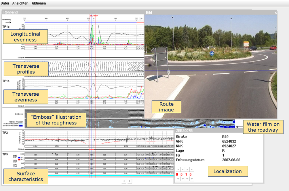
Figure 4.3.7.7.2 First CED/OnKo application in 2007 for state roads in Baden-Württemberg
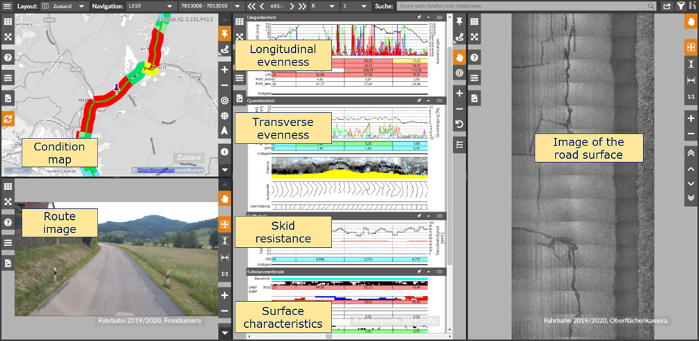
Figure 4.3.7.7.3 Examples of visual data control on the CDE/OnKo platform in 2020 for state roads in Baden-Württemberg
Assessment of pavement condition, statistical analysis and visualization
After the functional control of the data has been positively completed, the final assessment, statistical analysis and visualization of the data on maps and road profiles is performed (see the corresponding examples in Figure 4.3.7.7.4, Figure 4.3.7.7.5, Figure 4.3.7.7.6). The condition data then receive the status: published and can already be used for further, task-related assessments by the client (operator). The CDE/OnKo platform is equipped with all the necessary functions to realize these analytical assessments and visualizations automatically. The results are then made available in the required formats on the CDE/OnKo - platform for downloading by authorized parties, especially the operator's staff. The condition data in the Published status are considered as final results of the respective ZEB project.
The operator (client of the ZEB project) then decides which results of the entire ZEB project are transferred directly into the respective road information database (Asset Information Model) and are awarded the status archive. The verification of the ZEB results by the operator and their transfer into the Asset Information Model can be done outside the CDE/OnKo platform or by using the corresponding functionality of CDE/OnKo.
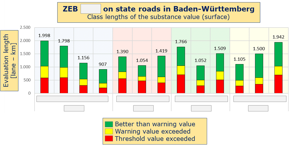
Figure 4.3.7.7.4 Example of statistical assessments
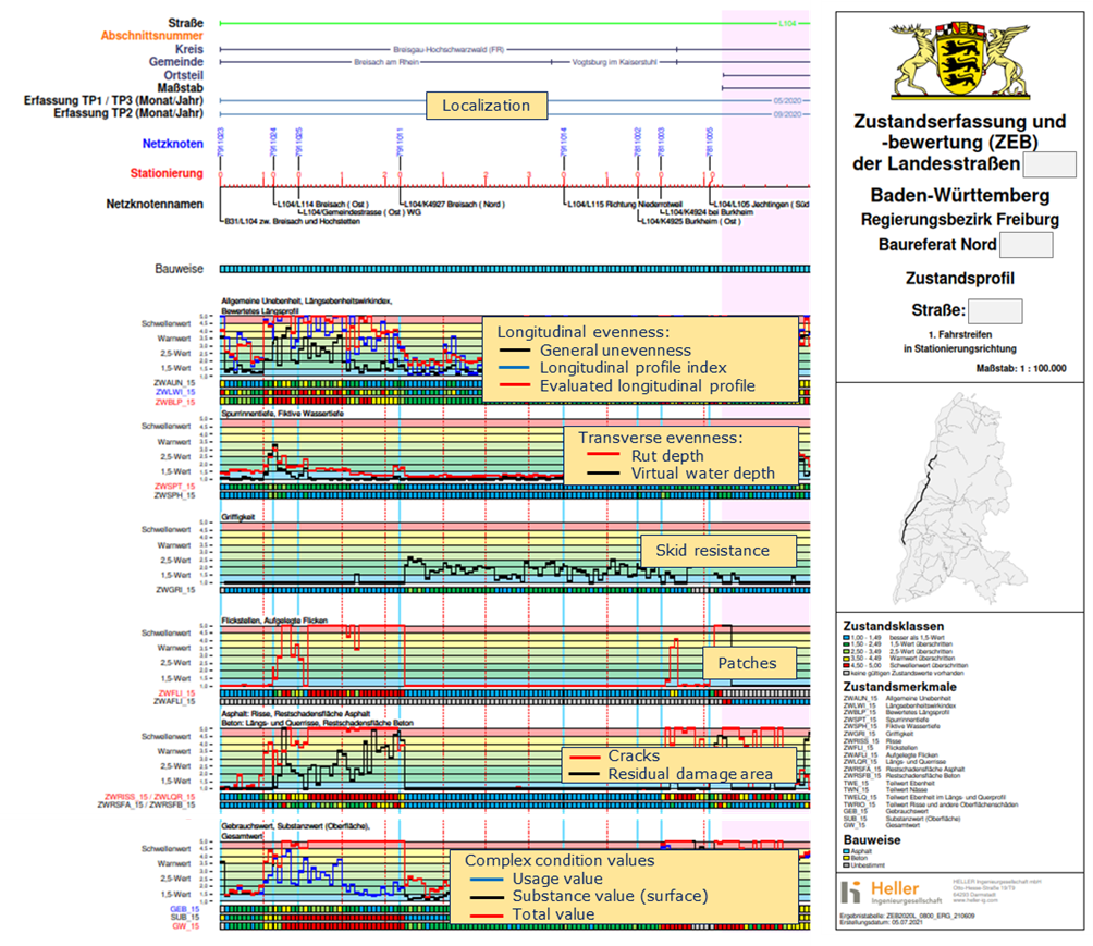
Figure 4.3.7.7.5 Example of a profile of condition values and condition classes
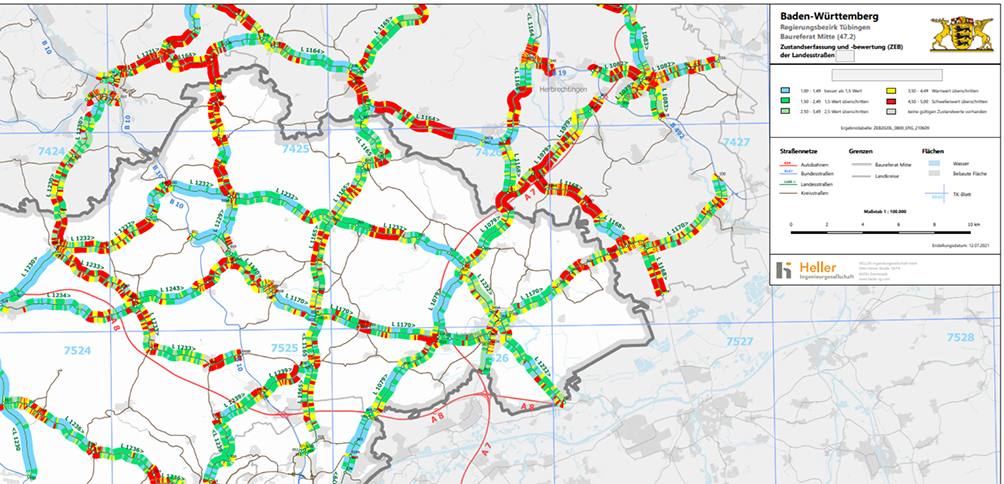
Figure 4.3.7.7.6 Example of a map with condition classes
The German ZEB is an example of the practical implementation of the general BIM approach described in the BS 1192:2007 and ISO 19650:2018 standards for monitoring and managing road infrastructure data. Both the general information management requirements formulated in these regulations (e.g., deriving the requirements for condition data from the organizational goals of the operator) and technical solutions (such as CDE) are used here.
This also follows an important principle of digitalization that is highlighted in several places in ISO 19650, namely an approach that is as broad as possible and not limited to large projects. It is namely expected that the solutions applied always correspond to the dimensions of the respective project. Considering this basic principle, scaling both the ZEB process and the data management requirements is not only possible, but necessary. Thus, the CDE/OnKo solution could be successfully applied for large projects on federal highways with over 30,000 lines-km as well as for small and micro projects on county, municipality or concession level with a length of a few hundred kilometers.
The high flexibility of the ZEB approach due to the central position of the GEO raw data and the simultaneously flexible and service-oriented architecture of the CDE/OnKo platform made it possible to implement this platform into the IT environment of the existing database systems of different operators after completion of the ZEB project. Thus, CDE/OnKo could be used as a platform for the intersection and visualization of condition data in the combination of inventory, traffic, measures and other data not only in Baden-Württemberg, but also by road infrastructure operators in other countries such as Austria (ASFINAG), Portugal (Infraestructuras de Portugal) or China (JSTI).
One of the principles of modern asset management is the need to continuously validate the technology and, above all, to verify that it is in line with the current objectives and strategies of the operator's organization. This, and also the need to reflect the current state of the art, results in the requirement to continuously improve the respective solution, even if it is working error-free at the moment. This is only possible in close and cooperative partnership with the client (operator), who is responsible for implementing the operating strategy.
PIARC, 2023."BIM and Digitalization", Technical Committee 3.3 Road Asset Management, WG 1 Innovative Approaches for Asset Management Systems. (https://www.piarc.org/ressources/publications/source/3/115863f4-44670-20...)
ISO 19650, 2018. Organization and digitization of information about buildings and civil engineering works, including building information modelling (BIM) - Information management using building information modelling.
ISO 55000, 2014. Asset Management - Overview, principles and terminology.
McKinsey, 2016. McKinsey Global Institute, Bridging Global Infrastructure Gaps, 06/2016.
NBS, 2021. BIM dimensions – 3D, 4D, 5D, 6D BIM explained. (https://www.thenbs.com/knowledge/bim-dimensions-3d-4d-5d-6d-bim-explained)
NBS, 2019. 9th Annual BIM Report (https://www.thenbs.com/knowledge/national-bim-report-2019#article-1).
NZ-BIM, 2019. The New Zealand BIM Handbook, A Guide to Enabling BIM on Built Assets, 2019 (https://www.biminnz.co.nz/s/NZ-BIM-Handbook-May-19.pdf).
BS 1192, 2007. Collaborative production of architectural, engineering and construction information - code of practice.
UK BIM Framework, 2019. Government Soft Landings. Revised guidance for the public sector on applying BS8536 parts 1 and 2. Updated for ISO 19650, 2019.
Miskimmin, 2017. Miskimmin, I.: Plain Language BIM, Bentley Institute Press, 2017.
Laney, 2017. Laney, D.B.: Infonomics: How to Monetize, Manage, and Measure Information as an Asset for Competitive Advantage, Gartner, Inc. 2017.
Heller, 2011. Heller, S.: Future developments in maintenance management and the monitoring and evaluation of pavement condition. In: Maintenance Management for Bavarian roads, Bauintern, special edition, 2011.
FGSV, 2006. FGSV: Zusätzliche Technische Vertragsbedingungen und Richtlinien zur Zustandserfassung und -bewertung von Straßen, Forschungsgesellschaft für Straßen und Verkehrswesen, 2006.