
The following case studies are presented in this chapter:
CASE STUDY 1: Implementation of Road Asset Management and Inventory Systems for the state roads of Pahang, Malaysia – Data collection
CASE STUDY 2: Road inventory and automatic visual inspection in Chile
CASE STUDY 3: Inventory, inspection and reporting of dynamic traffic management sign gantries at Flemish Roads and Traffic Agency (AWV)
The state government of Pahang, Malaysia, decided to implement a road asset management system for its state road network as part of a long-term road maintenance contract of seven years with a private company appointed in April 2013. The company was to maintain 2,300 km of the state road network and implement a road asset management system. The scope of road maintenance work included routine maintenance, periodic maintenance, and emergency maintenance. The contract also included the provision of an asset management system (YP-RAMS) and a road asset inventory management system (YP-RIMS).
The data collection for the asset management system involved the collection of road asset inventory data and a pavement condition survey to be carried out for the entire network in the first year. The collection of road asset inventory data and a pavement condition survey for 30 percent of the network was to be carried out from the second year until the end of the contract period. The use of GPS coordinates and digital recording for all asset points and referencing was compulsory. The road asset inventory management system needed to be updated and inventory reports produced every year. The new road asset management module needed to be inter-phased or integrated into a pavement management system, geographic information system (GIS), road asset inventory management system, and road inventory and road condition database.
The asset management software system makes use of a common inventory and database on the ArcGIS platform. The network condition data are measured in accordance with the International Roughness Index (IRI), cracks, and pavement strength. Digital recordings of the -of-way were taken for the entire network. Traffic data were collected from selected traffic count stations in terms of AADT and axle loading.
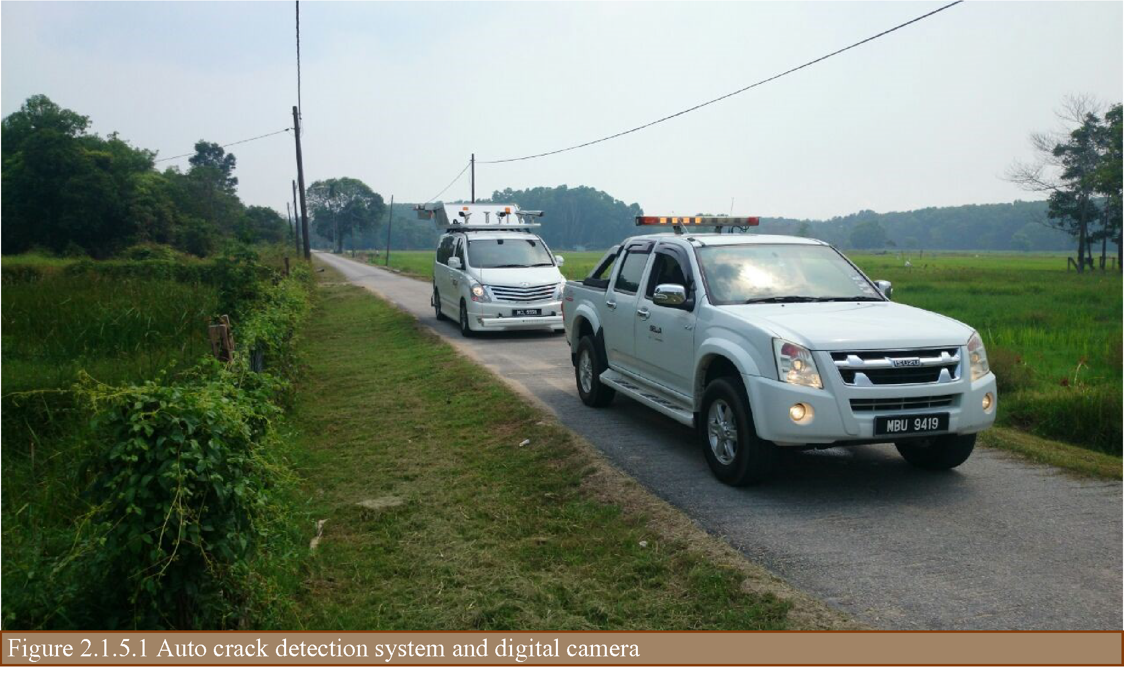
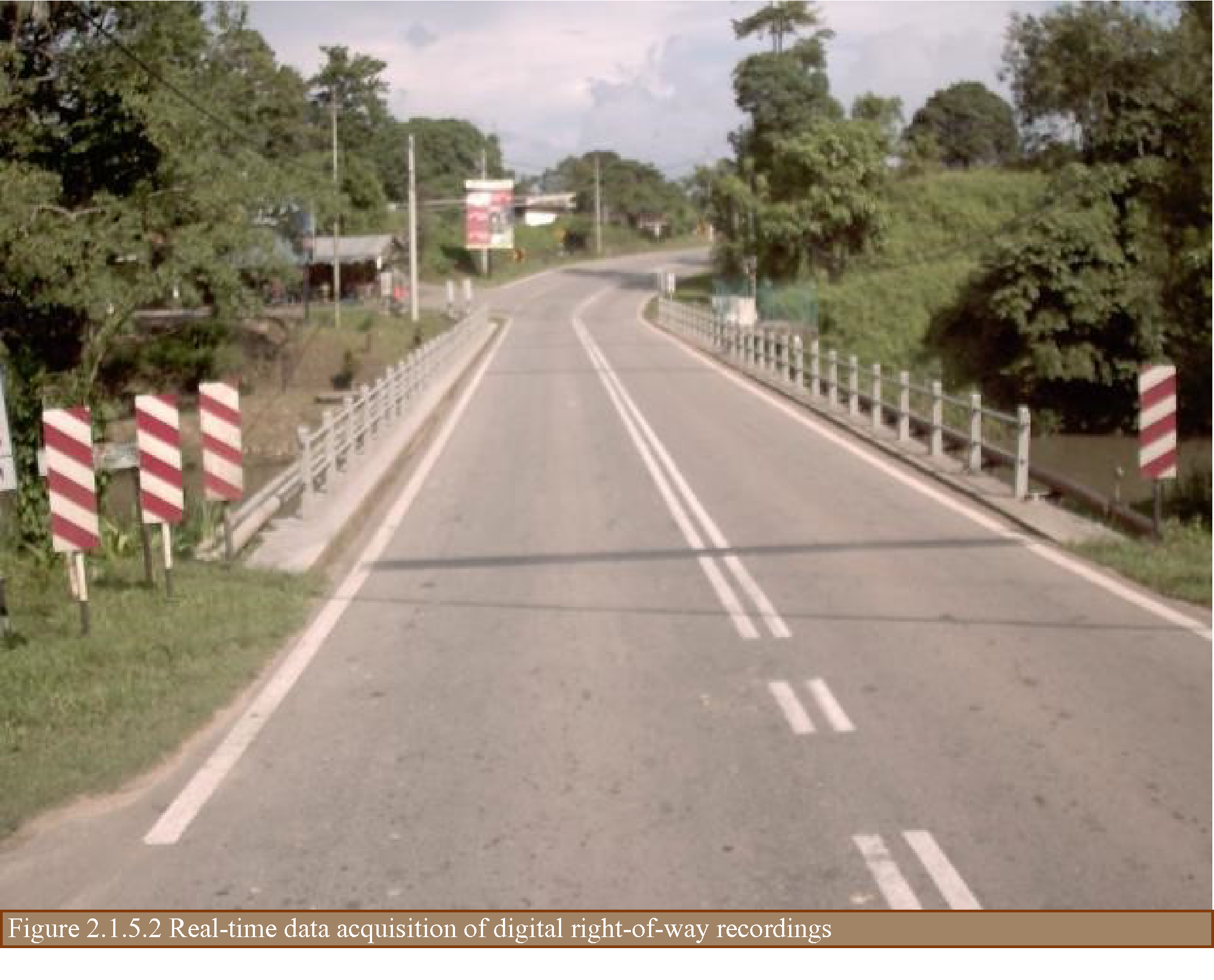
The project managers opted to outsource the data collection equipment rather than purchase new equipment. This proved to be cost-effective, considering the idle time between data collection intervals. The techniques and equipment used included a multi-laser profiler and automatic crack detection (ACD) system, FWD, asphalt coring, and a dynamic cone penetrometer. The techniques and equipment used are shown in Figures 2.1.5.1 and 2.1.5.2 The following data were collected:
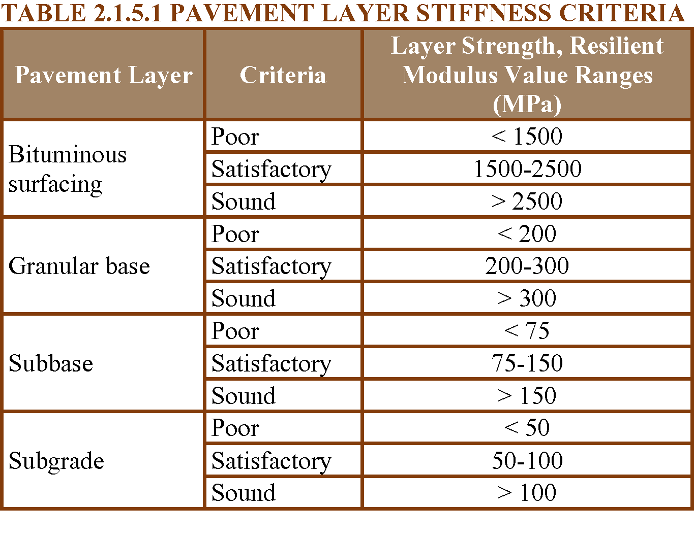
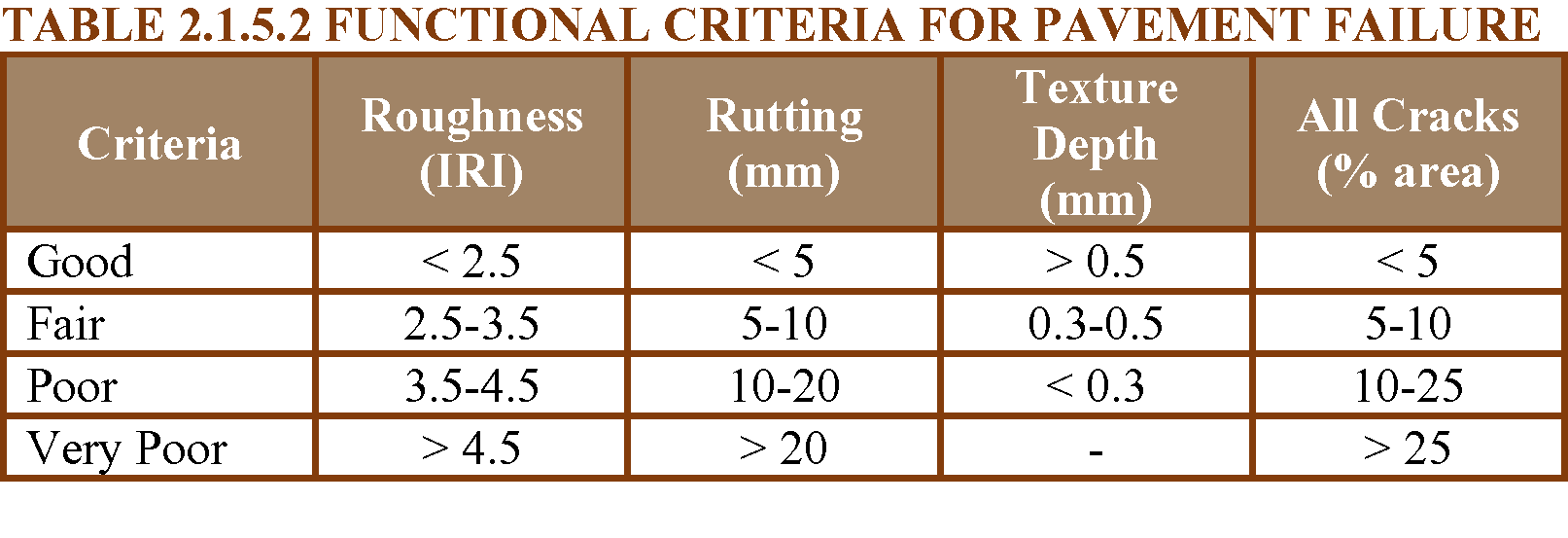
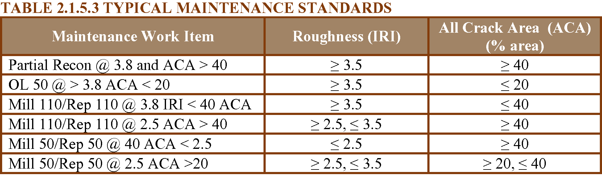
The criteria used for data collection and analysis are shown in Tables 2.1.5.1 to 2.1.5.3.
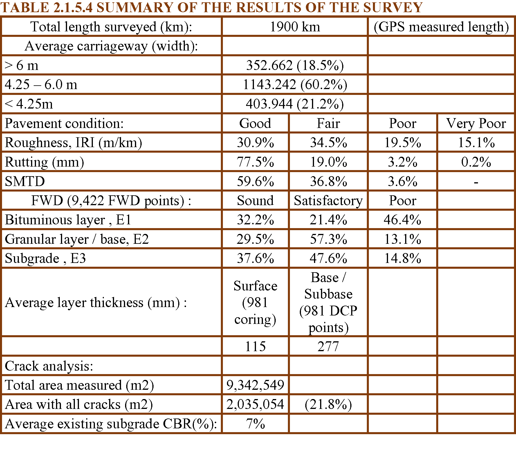
The collected road data were processed using the respective software of the equipment used. A summary of the outcome of the surveys is shown in Table 2.1.5.4.
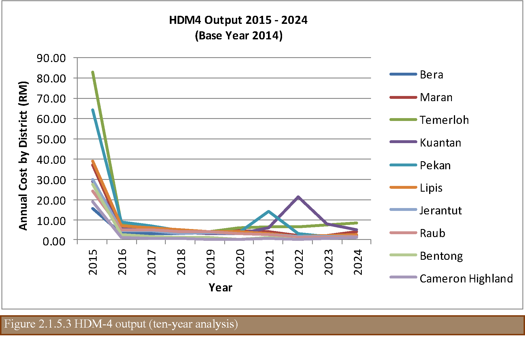
HDM-4 (Bennett 1999, 2007) was used to evaluate the maintenance requirements based on the maintenance standard specified. With the base year 2014, the predicted cost by each district is shown in Figure 2.1.5.3.
In conclusion, the proper and systematic collection of data using the correct and appropriate data collection equipment allows an adequate maintenance strategy to be applied.
CARLOS RUIZ TREVIZAN, National Highways Laboratory Department, Highway office, Chile
In recent years in Chile, activities have been intensified to improve traditional road maintenance management systems, innovating and diversifying the management systems of road conservation activities, incorporating road network systems, service levels, road concessions, execution and maintenance of basic roads (low cost roads) and maintenance by Direct Administration (using its own personnel and resources of the National Road Directorate of Chile).
One of the main axes to support this sustained growth in road management currently in Chile is the information provided by the Road Inventory and Visual Inspection of Paved Roads, which is done through automated equipment. This equipment with digital cameras, bars with lasers and bars with geophones are mounted on a vehicle which travels on the road at the same speed of flow and collects much of the information that is needed. IRI data can be obtained, cracking, road geometry, signaling, lighting, road safety, demarcation and shoulder data, among other parameters. The data is stored immediately and can be transferred to any database format required by the network administrator (see Figure 2.1.5.4).
The captured and georeferenced digital images are entered into a program to identify the types of deterioration present in the roadway and a severity is assigned to then compute the deteriorated areas. The structural and functional deteriorations are then entered into the ICP indicator (Pavement Condition Index) to determine the qualitative and quantitative condition of the pavement. The ICP indicator corresponds to an own design of the Road Directorate of Chile and is the product of an extensive and complete study of behavior of the pavements, framed this in the implementation of a robust system of management of the pavements.
Another technology that has gone in breakthrough is the Georradar, which is a non-destructive technique that is based on the emission and propagation of electromagnetic waves in a medium, with the subsequent reception of the reflections that occur in their discontinuities. The application in a first stage of 5,500 kilometers of pavements, complemented with the extraction of witnesses of pavements and exploration shafts on the side of the roads, allowed to update and correct a large part of the road inventory of paved roads in terms of characteristics and types of materials that make up the road surface.
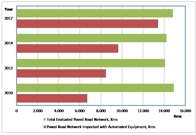
Currently in Chile, and after several periods performing the visual inspections of pavements by manual means and with personnel from the National Road Directorate itself, it has been decided for 4 consecutive periods to carry out a large percentage of this task through consulting contracts and with automated means. In 2017 they were tendered in the National Roads Authority of Chile 13,404 kilometers of automated auscultation of about 14,834 total kilometers evaluable, representing 90.4%. This growth in the automated visual inspection of pavements carried out in Chile can be seen in Figure 2.1.5.5.
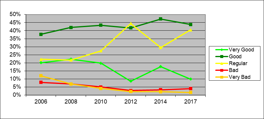
With the results of this automated visual inspection, a large amount of parameter information is obtained from the paved network, which allows the execution of the HDM-4 software to develop periodic maintenance projects that maximize social benefits and provide a greater social return of investment in the country's road infrastructure. These projects are proposed to each of the 16 Regional Road Directions in which the country is administratively divided to be considered in the prioritization of the works that will be executed in the short term and in the relevant budgetary processes. In addition, the automated visual inspection allows tracking the status of the paved road network of the country so that the community and the authorities of the country have a global knowledge of its evolution as shown in the following Figure 2.1.5.6:
This summarizes the activities and results obtained from the process described above, which is currently carried out in Chile to manage the entire paved network under the responsibility of the National Roads Department. More information on this can be found on the website of the Roads Department of Chile according to the link: http://www.vialidad.cl/areasdevialidad/gestionvial/Paginas/Informesyestudios.aspx
BEN HELSEN, Flemish Roads and Traffic Agency (AWV) - EMT, Belgium
The IIR (Inventory, Inspection and Reporting) project was started within the Flemish roads and traffic agency (AWV) in 2012, with a view to achieving efficient inventorying and inspection of road accessories (both electrical equipment and the actual road accessories, as well as road condition).As part of the group of electromechanical facilities, sign gantries for dynamic traffic management (DTM) were included in the project from the start, mainly on account of their potential risk (position above the carriageway).
The electromechanics and telematics (EMT) division of AWV – more specifically its traffic enforcement systems (VHS) team, which also provides the operational management of those facilities – was placed in charge. The objective of AWV is to take a detailed inventory of the full asset in place. Newly installed facilities (e.g. in new construction projects) are added to the inventory as standard procedure.
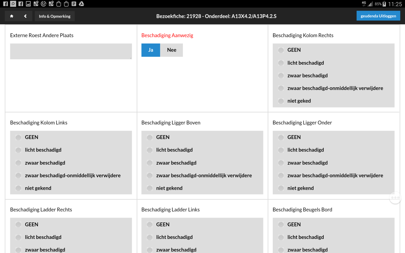
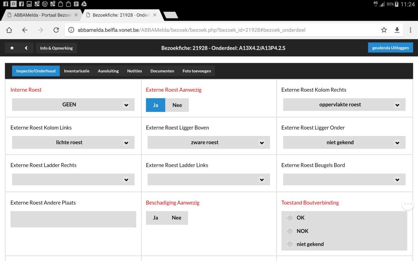
The inspections include assessing and recording the condition of the facility, with special focus on stability, corrosion and the condition not only of the columns, but also of the clamps and bolts.
The approach is a basic solution to manage the maintenance risk of electromechanical facilities, sign gantries for dynamic traffic management (DTM) on the Flemish roads.
Efficient inventorying and inspection of road accessories. The objective of AWV is to take a detailed inventory of the full asset in place.
The inspections include assessing and recording the condition of the facility, with special focus on stability, corrosion and the condition not only of the columns, but also of the clamps and bolts.
Structured detailed inventory of the asset (of DTM sign gantries in this case), with a representative inspected status of both the entire facilities and their relevant parts. Using this inventory, status reporting makes it possible not only to define an adequate maintenance policy but also to take targeted remedial (or, if necessary, proactive) measures through the maintenance programme – which is otherwise mainly directed to operationality – or, if necessary, through well-advised targeted (re-)investments.
Before the IIR project, AbbaMelda was already a first form of asset management, at least as far as the electromechanical facilities managed by AWV’s EMT division were concerned. However, it was a rather single level and little structured listing of facilities mainly intended for use in calling up the contractors concerned in case of defects or damage and in recording the calls and their handling. Moreover, the listing was high-level as far as the facilities were concerned, with little on no specification of component parts and, consequenly, few or no interrelations.
A safety incident triggered the setting up of the IIR project, which built on the existing AbbaMelda data base for electromechanical facilities such as DTM sign gantries.
The facilities already included were renamed in many cases, but also – and mainly - often merged into coherent logical sets. Many more component parts were specified and included (e.g., not only the sign gantry with variable message signs, but also the individual signs, their controller cabinet and the representative parts inside, and characteristics of, that cabinet. Electric power supply and the communication network were included as well.
Additionally, maximum accuracy (typically GPS) location data were assigned to the facilities and parts, enabling the data to be coupled in numerous GIS applications for various purposes (e.g., conflict detection in case of scheduled works).
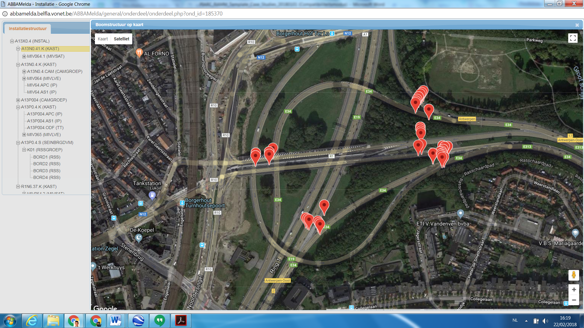
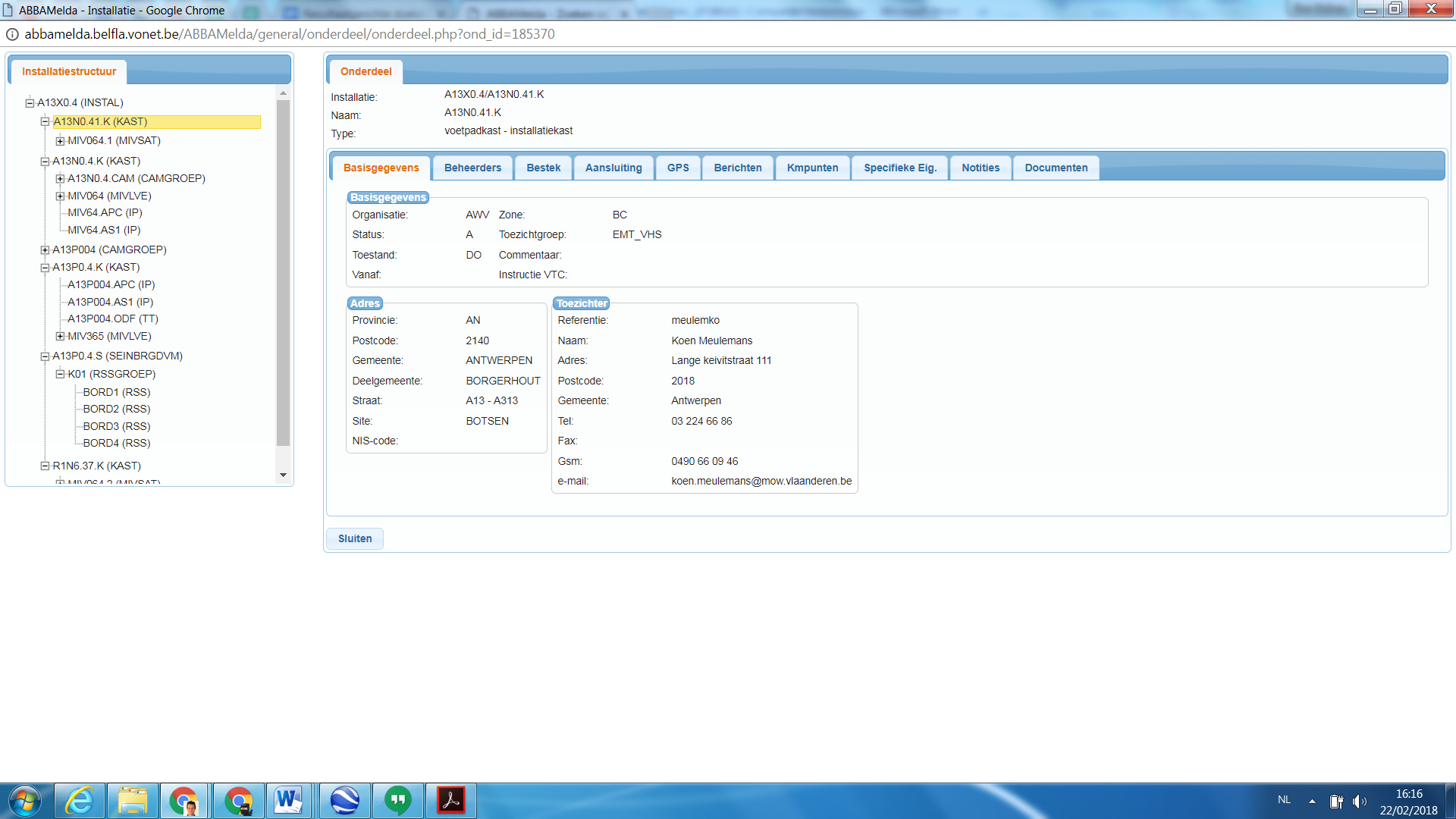
Figure 2.1.5.8: AbbaMelda data base for electromechanical facilities
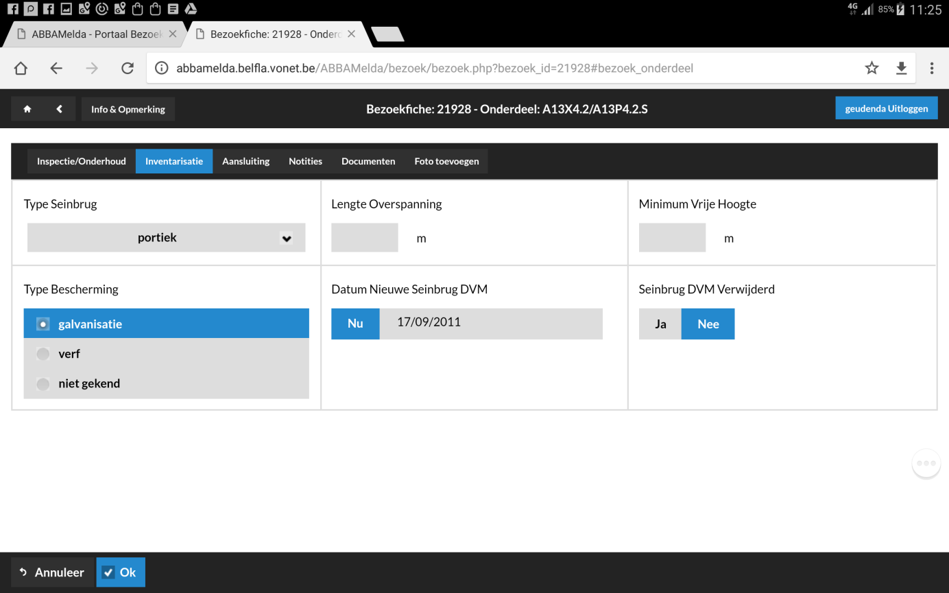
A portal named “Mobiel” was developed for use on a tablet, which made it possible not only to inventory (or continue inventorying) facilities on site, but also, and mainly, to inspect them.
A few screenshots for DTM sign gantries are presented below.
Two new projects were recently started. In the first project, the existing application AbbaMelda is divided into two parts, with the facility database part being renewed into a modern application which not only better suits the functional needs but wil also, and mainly, provide additional possibilities for interrelations, structures, etc. Concurrently, an AIM/BIM-oriented project was launched at AWV level.
Whereas a few years ago AbbaMelda was mainly a tool for recording and monitoring defect repairs, it has developed and is still developing further into a central data base of electromechanical facilities managed by AWV: type of facility, location, interrelations, status, parts, persons in charge, etc.